Wednesday, November 30, 2022

Uncertain Snow, Very Cold Temperatures Ahead

No FastCast tonight, but keep reading below for an update on the system currently moving through the region. Snow is in the beginning of the post, with very cold temperatures at the end.

------------------------------------------------------------

It has been a very interesting past 24 hours across the Puget Sound region. Overnight, 4-8 inches of snow fell from North Seattle to Marysville, with 6-12 inches near Hood Canal and in the Cascade foothills. 18-24 inches fell in the mountains, prompting a closure on Snoqualmie Pass.

On Wednesday afternoon, snow started in areas south of Seattle and in the foothills, accumulating 0.5-2.25 inches by 9 PM, when snow tapered. Let's take a look at the upcoming forecast.

Below is the European model forecast for low temperatures overnight Wednesday into Thursday morning.


I started with this because any water on the roads across the region will likely freeze, except on busier roads like highways. Lows are expected to be in the mid to upper 20s, except in the low 30s near the water. Lows in the low 20s are possible in Whatcom County, coupled with very cold wind chills in the upper single digits to mid teens. In Eastern Washington, expect lows in the mid teens to mid 20s, except warmer in the lower Columbia Basin.

Now for the snow forecast. It is important to know that forecast models have been having a hard time accurately forecasting snow with this system, so any solutions below are merely a possibility, and not an actual forecast.

So, with that being said, let's look at what's possible overnight, starting with the NAM forecast through 5 PM Thursday.


The NAM forecast is the most ambitious, showing 2-6 inches of snow in the foothills and from Centralia to Seatac. 

Next is the HRRR forecast, also showing snow through 5 PM Thursday.


This forecast is much less optimistic for snow, showing 0.5-1 inches from Seattle south to Portland, with more (1-2 inches) in the foothills and near Kelso/Longview.

Finally, let's take a look at the European model, showing snow through 4 PM Thursday.


The European model is a middle ground between the NAM and HRRR. This shows 0.5-3 inches of snow from Everett southward, with the most in the Cascade foothills and near Kelso/Longview and the North/Central Coast.

So, to summarize, another band of snow will potentially impact the region from late Wednesday night through Thursday morning. Uncertainty remains on the placement of this band and how much snow will accumulate, but 1-3 inches south of Seattle (most in the foothills) is a good guess.

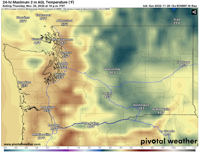
Additionally, Thursday will not be very warm, so any snow remaining won't melt too much. The European model's Thursday highs are below.


Highs in the lowlands will only reach the mid 30s, and won't get out of the low 30s in Whatcom County and most of Eastern Washington, except the lower Columbia Basin.

Then, the real cold sets in on Thursday night into Friday morning. The European model's forecast for Friday morning lows is below.


Wow! The European model forecasts lows in the low to mid 20s across the entirety of the lowlands, and potentially in the upper teens for the foothills and Whatcom County. Parts of Eastern Washington will be in the single digits to low teens. Stay tuned for much more information on these very cold temperatures.

In conclusion, the winterlike pattern will continue across Washington State. Stay tuned to Twitter, NWS Seattle, local news, and the blog for updates!

Tuesday, November 29, 2022

Storm Update: Heavy Snow, Strong Winds, and Heavy Rain Ahead

No FastCast today. Continue reading below for an update on this dynamic storm impacting Western Washington.

There is a plethora of different weather conditions impacting Western Washington on Tuesday evening. The radar image below shows the stark contrast between rain and snow.


As of 8 PM, heavy snow is falling from Everett to Shoreline, with accumulations on all roads, including I-5. Heavy snow is also falling on the Eastside and in the foothills, with chains now required on SR-18 over Tiger Mountain and accumulations in Issaquah and North Bend. 

South of the Seattle/Bellevue area, rain is falling. There is snow on parts of the Kitsap Peninsula and north of Bellingham, especially near the Canadian border, where significant snow is impacting the Vancouver BC metro area.

Earlier in the day, 0.5-1" of snow fell in parts of the South/Central Sound, more than previously forecast.

Let's take a look at the upcoming forecast. Below is the HRRR forecast for snow through 4 AM Wednesday.


This forecast shows 2-6 inches of snow from Shoreline to Stanwood, which seems to be verifying. The mountains will be hammered with 1-3 feet of snow in 12 hours, with very difficult to nearly impossible travel at the passes. Additionally, expect 2-8 inches on the Kitsap Peninsula.

The UW snow forecast through 4 AM Wednesday is below.


Note that this forecast includes snow in the South Sound that has already fallen Tuesday morning. 

The UW forecast also shows 2-6 inches from Shoreline to Stanwood, 1-2 feet in the mountains, and 2-8 inches on the Kitsap Peninsula, with the potential for up to 12 inches near Hood Canal.

Snow will accumulate 2-6 inches in the Cascade foothills, roughly from Black Diamond northward.

Now for the interesting part...snow will change to rain overnight, but the timing differs slightly between the high-resolution models. Generally, expect snow to change to rain area-wide by 2 AM Wednesday.

Now for the other significant weather hazard overnight...strong winds. Gusts over 50 mph have been reported in the San Juan Islands and Admiralty Inlet Area as of 8 PM Tuesday, and strong winds will continue across the region overnight. 

Below is the HRRR forecast for gusts at 11 PM Tuesday.


The HRRR shows winds peaking from 10 PM-2 AM, with peak gusts of 40-50 mph across the region, with isolated higher gusts possible, especially north of Everett.

Next, let's take a look at the NAM forecast, showing peak gusts at 2 AM Wednesday.


The NAM shows winds peaking from 11 PM-3 AM, roughly the same as the HRRR. The NAM shows peak gusts of 40-50 mph for the entire region, with higher gusts north of Everett and in parts of the Willamette Valley and Eastern WA/OR.

Rain is also expected with this system, heavy at times overnight. The HRRR rain forecast is below, showing rain through 12 PM Wednesday.


For areas where it is snowing, this won't all fall as rain, but will instead be the total amount of water going through a rain gauge. For areas from Seattle southward into the Willamette Valley, expect a total of 0.8-1.25 inches of rain, with 1.5-2.5 inches on the coast.

To recap, heavy snow will continue falling through around 12-2 AM for areas on the Kitsap Peninsula, north of Shoreline, in the foothills, and north of Bellingham into BC. It will be windy across the region overnight, with peak winds from 10 PM-3 AM across the region.

More snow chances are possible in post-frontal showers on Wednesday, potential Convergence Zone bands, and in future systems on Thursday and Friday, so stay tuned.

Monday, November 28, 2022

Complex Storm Bringing Snow, Rain, and Wind from Tuesday to Wednesday

No FastCast today. Keep reading below for information about a complex storm ahead on 

A complex storm is ahead for the Pacific Northwest. Western Washington will be impacted by lowland snow, rain, wind, and heavy mountain snow. So, let's break it down.

Most of this blog will detail the snow, but continue to the bottom for a brief note about gusty winds and rain.

To determine the most likely scenario, we will compare 4 accurate forecast models to gather a consensus. One consensus is already clear: snow will begin from south to north, roughly from 9 AM-12 PM. Snow will changeover to rain from 2-8 PM from Seattle southward and from 9 PM-1 AM from Seattle northward. Sticking snow is most likely north of Seattle and on the Kitsap Peninsula, so that is where the biggest road impacts are expected. The Cascades will also receive 1-2 feet of snow, making mountain pass travel very difficult.

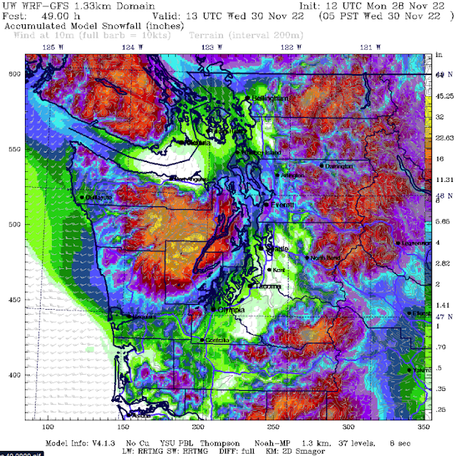
Let's start with the highest-resolution model, the UW model, showing snow through 5 AM Wednesday.


The UW forecast shows that areas from North Seattle to Mount Vernon (including Whidbey Island & the Admiralty Inlet area) will receive 2-8 inches of snow. Areas from Seattle southward will get a dusting to 1 inch of snow. Whatcom & San Juan Counties receive 1-5 inches with this forecast is the Kitsap Peninsula, where 4-12 inches are possible (even more near Hood Canal!). Areas from Olympia to Centralia will get 1-3 inches, and the coastal areas from Westport northward will get 1-6 inches.

Now for the NAM high-resolution forecast, showing snow through 5 AM Wednesday.


The NAM shows the most snow from Seattle to Mount Vernon and from Bellingham into BC, where 2-6 inches are possible. Areas from Seattle south will get a dusting to 1 inch, as will the coast. Areas from Olympia to Kelso will get 0.5-2 inches. The NAM also shows 3-10 inches on the Kitsap Peninsula, most closer to Hood Canal.

Below is the HRRR high-resolution forecast, also showing snow through 5 AM Wednesday.


The HRRR shows the most snow from Shoreline to the Canadian border, with 2-6 inches possible. Areas from Seattle south and on the coast receive a dusting to 1 inch in this forecast. The HRRR gives the Kitsap Peninsula 2-10 inches. 

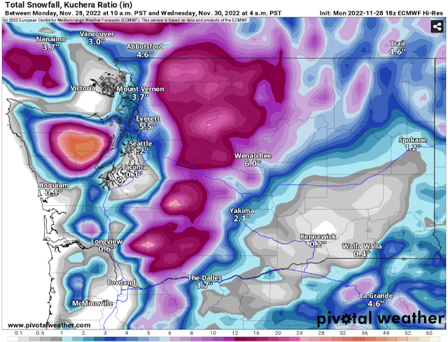
Finally, we'll look at the reliable, albeit lower-resolution European model, showing snow through 4 AM Wednesday.


The European model shows the most snow from Seattle to the Canadian border, with 2-6 inches possible in these areas. Areas from Seattle south receive a dusting to 1 inch, and areas from Olympia to Vancouver, WA and on the coast receive 0.5-2 inches. The Kitsap Peninsula will receive 2-12 inches in the European model forecast, most near Hood Canal.

So, below is the consensus from all the models:

Seattle to the Canadian Border: 2-6 inches

Seattle to Olympia: Dusting-1 inch

Kitsap Peninsula: 2-12 inches

Coast from Westport northward: Dusting to 2 inches

Olympia to Kelso: 0.5-2 inches

After snow ends, expect moderate to heavy rain across the entire region. The European model forecast below shows total precipitation (essentially the amount that will fall into a rain gauge) through 10 PM Wednesday.


Across the area, total precipitation will reach 0.75-1.25 inches. This storm will be a very rainy one on the coast and the Willamette Valley, with those areas receiving 1.5-2.5 inches of rain.

Finally, there will be strong winds from Tuesday evening through early Wednesday morning. Below is the NAM forecast for gusts at 10 PM Tuesday.


Winds will peak across the region from approximately 6 PM Tuesday to 4 AM Wednesday. Winds will gust up to 40-50 mph for the entire region, strongest near the water, on the coast, and north of Everett. These winds will play an interesting part with the snow situation, and will either scour out snow sooner than expected, or create dicey conditions where it is snowing. As always, winds will produce isolated tree damage/power outages, especially if trees are heavy with snow.

The best thing to do is to stay tuned to the latest updates, both on Twitter (top right of blog) and local news stations. I will have another blog Tuesday evening with an update on the overall situation. Stay tuned & stay safe! 

Sunday, November 27, 2022

Localized Lowland Snow, Cold Air on Monday

 FastCast—Monday, Nov. 28 to Tuesday, Nov. 29:

After a stormy and active weekend, another system will bring a localized chance of lowland snow on Monday morning. The best chance of lowland snow will be from Everett northward, with a lesser chance in the Cascade foothills. Snow could occur with any precipitation in these favored locations throughout the day, but is most likely on Monday morning. For areas from Everett northward, 1-4 inches of snow are possible. For areas in the foothills, a dusting to 2 inches of snow are possible. For areas that don’t receive snow, 0.1-0.25 inches of rain are possible. Expect highs in the mid 30s to near 40, and lows in the mid to upper 20s. Biting north winds will bring gusts of 20-25 mph around the Sound, and 40-55 mph in Whatcom County. Wind chills will range from the mid 20s to low 30s in the lowlands to the low teens to low 20s in Whatcom County. In the Cascades, expect another 1-2 feet of snow through Tuesday. Mountain pass travel will be difficult. Wind chills in the mountains will be in the single digits to mid teens. Another chance of lowland snow is possible on Tuesday, and again on Wednesday, so stay tuned for more information in the next blog post.

————————————————————

Continue reading the full blog below!

After an active weekend, cold air has entered the lowlands, bringing multiple marginal chances of lowland snow throughout the week. We will examine each chance with a preceding blog post, so that we can have the most accuracy per forecast. So, let’s start with Monday’s snow chance.

The best chance for accumulating snow will be from very late Sunday night to midmorning on Monday.

Below is the UW model, the highest-resolution snow model available in the Pacific Northwest. This is showing snow through 12 AM Tuesday.


The UW model shows the best chance of accumulating snow from Everett to Bellingham. This forecast shows a total of 0.5-4 inches in these areas. A lesser chance of lowland snow is possible for the foothills, with 0.25-2 inches possible.

Another forecast is available from the high-resolution HRRR model, showing snow through 11 PM Monday.


The HRRR shows a different scenario, with 1-3 inches in the foothills and a dusting to 0.5 inch from Everett south to Olympia. This scenario is less likely.

Finally, the we’ll look at the NAM high-resolution forecast, also through 11 PM Monday.


The NAM forecast generally agrees with the UW forecast, showing a localized band of a dusting to 3 inches of snow in northern Snohomish and southern Skagit Counties, and a dusting to 1 inch in the foothills.

Overall, the best chance of snow on Monday morning is from Everett northward to the Canadian border. A lesser chance exists in the Cascade foothills, and a slight chance exists from Everett southward through the metro area. 

Also on Monday, Fraser Gap outflow winds will strengthen across Whatcom and San Juan Counties. The main impacts of the winds will be isolated tree damage and power outages and cold wind chills. Expect gusts of 40-50 mph in Whatcom and San Juan Counties, and 20-25 mph around the rest of the region, strongest near the water. Below is the HRRR forecast for wind chills at 3 PM Monday.


By Monday afternoon, lowland wind chills will be in the mid to upper 20s. Whatcom and San Juan Counties will have wind chills in the low teens to low 20s all day, and Eastern Washington will also have wind chills in the low teens to upper 20s all day. At the passes and mountain communities, wind chills will be in the single digits to upper teens. Winds will decrease on Tuesday, but chilly conditions will still remain.

This week will be a “now-cast” scenario, with the best forecasts within hours of the upcoming weather. To stay updated, stay tuned to the blog and Twitter (accessed on the top right of the blog). 

Be prepared for winter conditions, especially in the mountains. Stay safe and stay warm!

Friday, November 25, 2022

Weekend Storm Bringing Heavy Mountain Snow and Gusty Winds

FastCast—Saturday, Nov. 26 to Monday, Nov. 28:

The next storm arrives on Saturday evening, bringing heavy mountain snow, lowland rain, and area-wide gusty winds. With the Apple Cup late on Saturday and the post-Thanksgiving travel, impacts on the passes are expected. The passes will receive 10-24 inches of snow (higher amounts possible) from Saturday night through Sunday night. The heaviest snow will fall on Sunday. In the lowlands, the main impact will be gusty winds from late Saturday evening to early Sunday morning. Peak gusts around the region will be 30-40 mph, except up to 45-50 mph from Port Angeles to Everett, including Whidbey Island due to a westerly wind surge. The lowlands will pick up 0.25-0.5 inches of rain, and the coast will receive 0.5-1.25 inches. Temperatures will be slowly falling throughout Sunday and Monday. This will make it possible for localized areas in the lowlands to see some snow accumulations on Monday morning in Convergence Zone bands. However, this is very uncertain, so stay tuned for the Sunday evening blog for more information. For Saturday to Monday, expect highs in the upper 40s, cooling to the low 40s, and lows in the upper 30s, cooling to the low 30s. Stay tuned!

————————————————————

Continue reading the full blog below!

An impactful storm is ahead this weekend, with the biggest impacts being heavy mountain snow and gusty winds. Let’s take a look at the forecast. 

Below is the NAM forecast for snow through 11 PM Sunday. Most snow at the passes will fall from Saturday night onward.


This forecast shows a total of 18-36 inches at the passes by late Sunday. 

As always, no forecast is truly accurate unless it agrees with other forecasts. The European model forecast for snow through Sunday night is below.


The European model shows 12-24 inches for the passes. This is perhaps a bit more reasonable than the NAM prediction. However, either is possible. Regardless, the heaviest snowfall rates will be from early Sunday morning through the night, with only brief breaks possible around midday. 

Travelers need to be prepared for winter storm conditions over the passes on  Saturday night and all day Sunday. This is especially important with the influx of traffic due to post-Thanksgiving travel and the Apple Cup.

In addition to heavy mountain snow, there will be gusty winds across the region this weekend. Peak winds for the lowlands are expected from late Saturday evening through early Sunday morning.

Below is the European model forecast, showing peak winds overnight from Saturday to Sunday.


The European model forecast shows peak winds of 35-40 mph for the Central Sound, with higher gusts up to 45-50 mph for areas from Port Angeles to Everett due to a westerly wind surge. Eastern Washington and the coast will gust 40-45 mph. 

A higher-resolution forecast (NAM) is shown below, showing peak winds in the lowlands. 


The NAM shows peak winds in the lowlands around 11 PM Saturday, with gusts of 35-45 mph from Tacoma northward. The westerly wind surge (45-50 mph gusts from Port Angeles to Everett) will occur early Sunday morning.

Gusts of 30-45 mph are enough to cause isolated tree damage and power outages, so be prepared.

There will be some rain with this system as well, but much less than Friday’s storm. The rain forecast through 11 PM Sunday from the NAM model is below.


Expect 0.25-0.5 inches in the lowlands and 0.5-1.25 inches on the coast. Note that the high rain amounts in the mountains will fall as snow.

Stay tuned for my next blog post on Sunday evening with an update on the upcoming arctic outbreak in the Pacific Northwest.

Thursday, November 24, 2022

Active Weather and a Potential Arctic Outbreak Ahead

 FastCast—Friday, Nov. 25 to Sunday, Nov. 27:

An active end to November is ahead for Western Washington, and for the Pacific Northwest at large. A wet system will move through on Friday, bringing 0.5-1.25 inches of rain to the lowlands, with the most from Tacoma northward. The snow level will be moderate with this system, likely staying above Snoqualmie Pass but impacting Stevens and White Passes with 1-6 inches of snow. The next system arrives late Saturday, bringing 0.25-0.5 inches of rain to the lowlands and significant mountain snow, with 8-18 inches possible at the passes. More information on the weekend storm can be found in the next blog post. After Sunday, a significant arctic outbreak is likely to impact the Pacific Northwest. We will explore this more in the coming days. In the meantime, expect highs from Friday to Sunday in the mid to upper 40s, with lows in the mid to upper 30s. Stay tuned, as lots of active weather is ahead!

———————————————————

Continue reading the full blog below!

The next system will arrive the Pacific Northwest on Friday, bringing steady rain to the lowlands.

The NAM high resolution forecast is below, showing rain through 11 PM Friday.


This forecast shows the bullseye from Tacoma northward, with the NAM showing 0.75-1.25 inches in the lowlands, and 0.3-0.6 inches elsewhere. 

Let’s compare this with the HRRR forecast (also through 11 PM Friday).


The HRRR shows a similar situation, just with rain dialed back a bit overall. This forecast still shows 0.5-1 inches in the lowlands.

Mountain snow will be less of an issue on Friday than over the weekend. Below is the European model forecast, showing total snowfall through 10 PM Sunday.


Snow levels with the Friday system will be around 3,500 feet, bringing a wintry mix to Snoqualmie Pass and 1-6 inches of snow to Stevens and White Passes. The weekend storm will likely bring 8-18 inches of snow to the passes, with snow levels around 1,500-2,000 feet. Travel will be most impacted from Saturday night to Sunday night on all passes. Stay tuned for more information on that storm.

Forecasts are now coming into agreement on an arctic outbreak for the Pacific Northwest next week. Below is the European model forecast showing temperature anomalies at 5,000 feet on Tuesday morning (black box is the Pacific Northwest).


The light blue and purple colors show temperatures far below normal entering the Pacific Northwest, from what is called a polar lobe, a part of the polar vortex that rotates the North Pole. When polar lobes move into BC and the Pacific Northwest, it brings very cold air to our region.

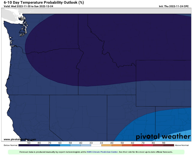
To show the certainty of the expected cold temperatures, the NWS Climate Prediction Center temperature probability outlook is below.


The CPC outlook for November 30-December 4 is above. This outlook shows a 70-90% probability of below average temperatures into the first week of December.

A lot of active and impactful weather is ahead for the next couple weeks, so stay tuned to Twitter and the blog. 

Tuesday, November 22, 2022

Dry Thanksgiving & A Potentially Stormy Holiday Weekend

 FastCast—Wednesday, Nov. 23 to Sunday, Nov. 27:

After an impactful storm that brought significant rain and impactful mountain snow to Washington state, weather will calm down through Thanksgiving, providing a good window of calm weather for cross-state travel. Expect a mostly cloudy Wednesday and partly to mostly sunny Thanksgiving Day. Wednesday and Thanksgiving will have highs in the low to mid 50s, with morning lows on Wednesday in the upper 30s to low 40s, and in the low to mid 30s on Thanksgiving. Showers return on Friday, continuing through the day. There will them be a break until late Saturday, and another system will impact the region into Sunday. Expect mostly cloudy conditions from Friday to Sunday, with highs in the mid to upper 40s and lows in the mid to upper 30s. Rain, mountain snow, and gusty winds are all potentially in the cards after Thanksgiving, so stay tuned, as impacts to travel are possible.

————————————————————

Continue reading the full blog below!

Thanksgiving is usually wet and cloudy in Western Washington, but 2022 will be an exception. Partly to mostly sunny skies are expected, with warmer conditions than usual for parts of Western Washington. The NAM forecast for high temperatures on Thanksgiving is below.


Expect highs in Western Washington to generally be in the low to mid 50s, with some areas staying in the upper 40s. Eastern Washington will be much colder, with highs likely not making it out of the 30s. 

An important note is that conditions will be good for cross-state travel prior to Thanksgiving, though upcoming systems after Thanksgiving do bear watching.

Let’s take a look at the extended forecast for after Thanksgiving from the GFS model.

Rain will likely return to the lowlands, as seen in the rain forecast through 11 PM Sunday.


Expect 0.4-1.5 inches of rain in the lowlands, most in potential Convergence Zone areas between Seattle and Mount Vernon. The coast will receive 0.8-1.25 inches, and Eastern Washington will get 0.1-0.5 inches. 

The more impactful weather for post-Thanksgiving travel will be potential mountain snow. The GFS snow forecast through 11 PM Sunday is below. (Ignore the lowland snow near Everett, that is not in consensus forecasts).


The GFS shows significant snow of 12-24 inches at the passes and up to 24-36 inches at higher elevations. Areas north of I-90 in Eastern Washington have a potential to see a dusting to 8 inches of snow, with the most by far in the mountainous areas and closer to Idaho. 

There is a lot of uncertainty with weather beyond Thanksgiving, so stay tuned for more information as details become more refined.

A note on Tuesday’s storm: 

This storm significantly overperformed from forecast model projections. Total rain around the Puget Sound area ended up reaching 0.75-1.5 inches, much more than the 0.4-0.8 inches in the highest predictions.


This rain did cause some localized flooding and standing water, but was mainly beneficial after a record November dry streak. 

Another interesting aspect of this storm was the stubborn cold air that remained in the valleys around Snoqualmie and Stevens Passes, producing a mix of heavy snow and freezing rain that clogged up the highways, as seen in the WSDOT image on Snoqualmie Pass on Tuesday afternoon.


This was originally going to be rain, but cold air near the surface worked its magic and kept snow going all day, eventually forcing a closure of I-90 eastbound around 5 PM Tuesday due to heavy snow and collisions.

This storm was an important reminder that despite the skill of our forecast models, they still have errors and can’t always account for the microclimate features of the Pacific Northwest.

Have a Happy Thanksgiving and stay tuned for more information about the post-Thanksgiving storm outlook!

Sunday, November 20, 2022

Rain to Return After Record Dry Spell

 FastCast—Monday, Nov. 21 to Friday, Nov. 25:

Rain hasn’t fallen in the past 13 days, tying an all-time November record for Seattle. However, that will change on Tuesday. Our first system in 2 weeks will bring 0.2-0.5 inches for the lowlands, with 0.5-0.75” from Everett northward and 0.8-1” on the coast. Breezy conditions, with gusts of 30-35 mph, are possible around the area on Tuesday. The snow level with this system will remain around 4,500 feet, so accumulations at the passes will only be 2-6 inches. However, with days of cold air prior to this system, it is possible to have higher snow accumulations if the cold air is trapped in the valleys near the passes. Conditions state-wide will dry out for the Thanksgiving travel rush on Wednesday and for Thanksgiving Day. Another round of rain is likely to arrive very late on Thanksgiving, with showers at times through Friday. You’ll notice much more clouds and a change in temperatures. Highs this week will reach the upper 40s to mid 50s, with lows in the upper 30s to low 40s. 

—————————————————————

Continue reading the full blog below!

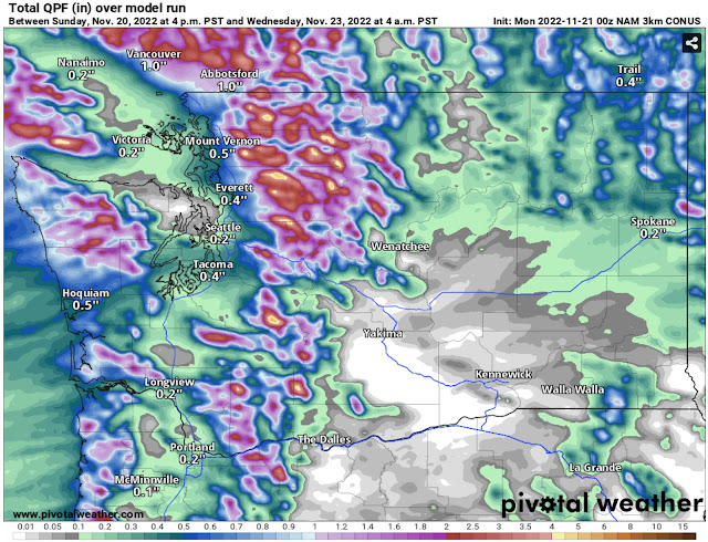
After a record-tying dry spell for November, rain is on its way back to Western Washington. A system will impact the region on Tuesday, bringing rain and high mountain snow. 

Below is the high-resolution NAM model forecast for rain through Wednesday morning. Expect most rain from early Tuesday through the evening, tapering by night.


Expect 0.2-0.5 inches in the lowlands, with less for the Northern Kitsap Peninsula and between Seattle and Everett. Areas in the foothills and north of Everett will receive 0.4-0.9 inches! The coast will get 0.4-1.2 inches, and the mountains will pick up 1-3 inches. 

The European model (below), also showing rain through Wednesday, shows a similar situation.


The European model also shows 0.2-0.5 inches in the lowlands, with less of a rain shadow and less from Everett northward (0.3-0.6”). The European gives the coast and mountains a bit less, around 0.75-1.25 inches. However, this forecast shows a bit more of a Convergence Zone signature between Seattle and Everett. A Convergence Zone would be most likely on Tuesday evening.

Regarding snow, this will be a bit warmer of a system, so snow levels will remain around 4,500-5,000 feet. Below is the NAM forecast for snow accumulation through Wednesday morning.


With a higher snow level, accumulations at the passes will be minimal, likely 2-6 inches. If cold air from the previous few days remains stuck in the valleys around passes, then accumulations at the passes may be higher. A dusting to 2 inches of snow is possible in the higher elevations of NE WA, including a dusting possible around Spokane.

Conditions will dry out by Wednesday, with good conditions expected for travel on Wednesday and Thanksgiving. It will actually be on the balmy side for Thanksgiving, as seen in the European model forecast below.


Highs in the mid to upper 50s are possible! Conditions may be partly to mostly sunny, so a pleasant Thanksgiving is possible for Western Washington, though an inversion layer will keep it much colder for Eastern Washington, with highs only in the upper 30s to mid 40s.

Stay tuned!

Wednesday, November 16, 2022

Gusty Gap Winds & Dry Conditions Ahead

FastCast—Thursday, Nov. 17 to Sunday, Nov. 20:

After a few days of calm weather, featuring sunny days, cold mornings, and areas of fog, things will get mixed up on Thursday. High pressure moving south into the US interior will cause a pressure gradient across the Cascades. This will bring easterly gusts of 40-50 mph to the foothills and Whatcom County. Parts of the Central Sound, the Central Coast, and parts of Eastern Washington will have gusts up to 30-40 mph. The Portland and Columbia River Gorge areas will have gusts of 40-50 mph. Conditions through Sunday will be mostly sunny with areas of fog and low clouds. Highs will reach the upper 40s to low 50s, with cold morning lows in the mid 20s to low 30s. Morning wind chill values could drop to the low to mid 20s at times, especially Thursday and Friday mornings. There is a significant pattern change ahead for Monday, so stay tuned as the active weather returns.

——————————————————

Continue reading the full blog below!

Gusty gap winds will increase across the foothills and Whatcom County overnight into Thursday morning. Let’s take a look at the peak winds.

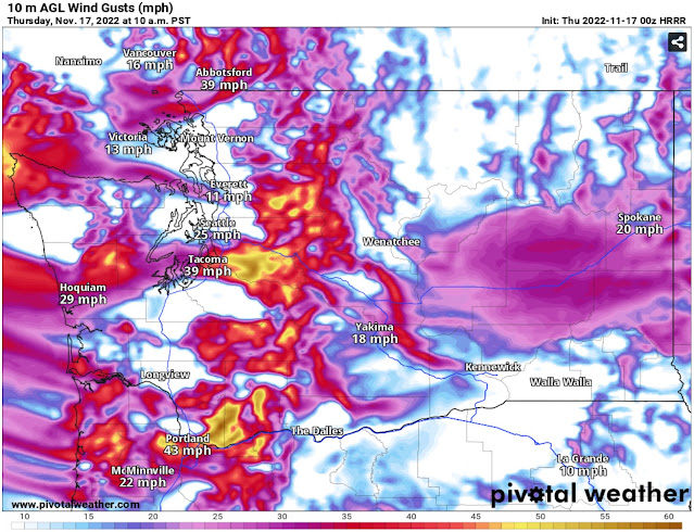
The HRRR forecast for gusts at 10 AM Thursday is below.


Expect gusts in the foothills and Whatcom County to peak at 40-50 mph. Gusts in the Central Sound from Seattle to South Tacoma will reach up to 30-40 mph, strongest from approximately 8-11 AM.

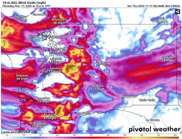
The NAM high-resolution forecast is also below.


The NAM agrees with the HRRR for winds in the foothills, Whatcom County, and Central Sound, while increasing winds to 30-40 mph for Grays Harbor County and the Central Coast. 

Additionally, the Portland area and S. WA Coast/N. OR Coast will gust 30-40 mph, with areas near the Columbia River Gorge reaching 40-50 mph. The high-resolution models are quite similar with these winds in most of the vulnerable regions, so there’s a good bet these predictions will be accurate.

Across the region, isolated power outages and tree damage are possible, especially since these winds aren’t from the typical direction. Be prepared!

These winds will also bring significantly drier conditions than normal. The humidity forecast from the HRRR at 6 PM Thursday is below.


Notice low relative humidity in the Central Sound is in the 30-40% range, potentially lower. This will also bring dewpoints of 5-15ยบ, quite dry for this time of year (but decreasing the potential of roadway icing on Friday morning).

Morning lows through Sunday will continue to be in the mid 20s to low 30s, with areas of freezing fog and low clouds. 

A big change is ahead by Monday, with stormy weather returning, so stay tuned.

Monday, November 14, 2022

Abnormal November Weather Continues

FastCast—Tuesday, Nov. 15 to Saturday, Nov. 19:

The chilly and dry weather will continue for Western Washington over the rest of the week. Conditions will be mostly sunny with morning clouds and fog. Highs in the lowlands will reach the upper 40s to low 50s, with morning lows in the upper 20s to low 30s. Temperatures will be colder in Eastern Washington, but slightly warmer in the mountains (due to the inversion effect). Air quality has degraded into the moderate category for most of the region due to stagnant air and lack of winds. However, that will change, with offshore winds likely enhancing the mixing of air on Thursday. NE offshore winds will gust 20-30 mph across the region. This same chilly and dry pattern will continue through Saturday, before. A pattern change back to a wetter and more active pattern is expected by Sunday, so stay tuned.

————————————————————

Continue reading the full blog below!

The past few days have been quite abnormal for Western Washington, with no rain for over a week. That will continue through the end of this week, with dramatic high pressure ridging bringing mostly sunny and dry weather. The huge ridge is seen on the European model below, showing late Tuesday.


This ridge is massive, stretching from the Pacific Northwest to the Aleutian Islands. This will bring the continuation of the recent pattern of cold nights, dry days, and areas of morning fog. 

Below is the NAM forecast for low temperatures on Wednesday morning.


This clearly shows the expected inversion, with lows around freezing in the lowlands and Eastern Washington, but warmer low temperatures in the mountains due to the inversion. This will bring a higher chance of fog and low clouds, especially in the mornings through Saturday.

A reminder of what an inversion is can be found below, in the graphic from NC State University.


In this case, the lowlands are in the cooler air layer and the warmer air inversion layer encompasses the Cascades. The inversion also plays a role in air quality.

Air quality is decreasing around the lowlands, due to the lack of winds over the past few days. Below is the PurpleAir map showing AQI at 9 PM Monday.


You can see the effects of the inversion, with cleaner air in North Bend and Issaquah and moderate AQI in the lowlands (except near the water). 

Degraded AQI will be possible through late Wednesday. On Thursday, an arctic front will move south into the Continental US, bringing a stronger pressure gradient across the Cascades. This will bring gusty offshore winds, seen below in the European model forecast for gusts on Thursday afternoon.


This forecast shows traditional gap winds, with 20-30 mph gusts for the foothills, Whatcom County, the Central Coast & Chehalis Gap, the Portland area, and of course the Cascades. This will mix up the air and likely bring some improvement to air quality. These winds will also erode the inversion layer. 

By Sunday, change is ahead. The NWS Climate Prediction Center outlook for November 20-24 (next Sunday to Thanksgiving Day) is below.


The CPC is showing a 40-50% probability of above average precipitation for the week of Thanksgiving, as a return to active weather is expected by Sunday.

In the meantime, enjoy this very abnormal November sun!

Next Storm System Hits Western Washington

  8-26 Video Briefing: Next Storm System Hits Western Washington