FastCast—Tuesday, Nov. 15 to Saturday, Nov. 19:
The chilly and dry weather will continue for Western Washington over the rest of the week. Conditions will be mostly sunny with morning clouds and fog. Highs in the lowlands will reach the upper 40s to low 50s, with morning lows in the upper 20s to low 30s. Temperatures will be colder in Eastern Washington, but slightly warmer in the mountains (due to the inversion effect). Air quality has degraded into the moderate category for most of the region due to stagnant air and lack of winds. However, that will change, with offshore winds likely enhancing the mixing of air on Thursday. NE offshore winds will gust 20-30 mph across the region. This same chilly and dry pattern will continue through Saturday, before. A pattern change back to a wetter and more active pattern is expected by Sunday, so stay tuned.
————————————————————
Continue reading the full blog below!
The past few days have been quite abnormal for Western Washington, with no rain for over a week. That will continue through the end of this week, with dramatic high pressure ridging bringing mostly sunny and dry weather. The huge ridge is seen on the European model below, showing late Tuesday.

This ridge is massive, stretching from the Pacific Northwest to the Aleutian Islands. This will bring the continuation of the recent pattern of cold nights, dry days, and areas of morning fog.
Below is the NAM forecast for low temperatures on Wednesday morning.

This clearly shows the expected inversion, with lows around freezing in the lowlands and Eastern Washington, but warmer low temperatures in the mountains due to the inversion. This will bring a higher chance of fog and low clouds, especially in the mornings through Saturday.
A reminder of what an inversion is can be found below, in the graphic from NC State University.
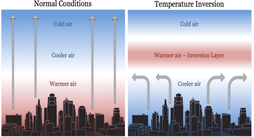
In this case, the lowlands are in the cooler air layer and the warmer air inversion layer encompasses the Cascades. The inversion also plays a role in air quality.
Air quality is decreasing around the lowlands, due to the lack of winds over the past few days. Below is the PurpleAir map showing AQI at 9 PM Monday.

You can see the effects of the inversion, with cleaner air in North Bend and Issaquah and moderate AQI in the lowlands (except near the water).
Degraded AQI will be possible through late Wednesday. On Thursday, an arctic front will move south into the Continental US, bringing a stronger pressure gradient across the Cascades. This will bring gusty offshore winds, seen below in the European model forecast for gusts on Thursday afternoon.

This forecast shows traditional gap winds, with 20-30 mph gusts for the foothills, Whatcom County, the Central Coast & Chehalis Gap, the Portland area, and of course the Cascades. This will mix up the air and likely bring some improvement to air quality. These winds will also erode the inversion layer.
By Sunday, change is ahead. The NWS Climate Prediction Center outlook for November 20-24 (next Sunday to Thanksgiving Day) is below.

The CPC is showing a 40-50% probability of above average precipitation for the week of Thanksgiving, as a return to active weather is expected by Sunday.
In the meantime, enjoy this very abnormal November sun!

No comments:
Post a Comment