FastCast—Friday, Nov. 25 to Sunday, Nov. 27:
An active end to November is ahead for Western Washington, and for the Pacific Northwest at large. A wet system will move through on Friday, bringing 0.5-1.25 inches of rain to the lowlands, with the most from Tacoma northward. The snow level will be moderate with this system, likely staying above Snoqualmie Pass but impacting Stevens and White Passes with 1-6 inches of snow. The next system arrives late Saturday, bringing 0.25-0.5 inches of rain to the lowlands and significant mountain snow, with 8-18 inches possible at the passes. More information on the weekend storm can be found in the next blog post. After Sunday, a significant arctic outbreak is likely to impact the Pacific Northwest. We will explore this more in the coming days. In the meantime, expect highs from Friday to Sunday in the mid to upper 40s, with lows in the mid to upper 30s. Stay tuned, as lots of active weather is ahead!
———————————————————
Continue reading the full blog below!
The next system will arrive the Pacific Northwest on Friday, bringing steady rain to the lowlands.
The NAM high resolution forecast is below, showing rain through 11 PM Friday.
This forecast shows the bullseye from Tacoma northward, with the NAM showing 0.75-1.25 inches in the lowlands, and 0.3-0.6 inches elsewhere.
Let’s compare this with the HRRR forecast (also through 11 PM Friday).
The HRRR shows a similar situation, just with rain dialed back a bit overall. This forecast still shows 0.5-1 inches in the lowlands.
Mountain snow will be less of an issue on Friday than over the weekend. Below is the European model forecast, showing total snowfall through 10 PM Sunday.
Snow levels with the Friday system will be around 3,500 feet, bringing a wintry mix to Snoqualmie Pass and 1-6 inches of snow to Stevens and White Passes. The weekend storm will likely bring 8-18 inches of snow to the passes, with snow levels around 1,500-2,000 feet. Travel will be most impacted from Saturday night to Sunday night on all passes. Stay tuned for more information on that storm.
Forecasts are now coming into agreement on an arctic outbreak for the Pacific Northwest next week. Below is the European model forecast showing temperature anomalies at 5,000 feet on Tuesday morning (black box is the Pacific Northwest).
The light blue and purple colors show temperatures far below normal entering the Pacific Northwest, from what is called a polar lobe, a part of the polar vortex that rotates the North Pole. When polar lobes move into BC and the Pacific Northwest, it brings very cold air to our region.
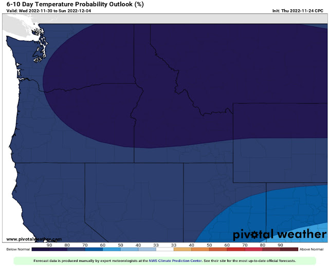
To show the certainty of the expected cold temperatures, the NWS Climate Prediction Center temperature probability outlook is below.
The CPC outlook for November 30-December 4 is above. This outlook shows a 70-90% probability of below average temperatures into the first week of December.
A lot of active and impactful weather is ahead for the next couple weeks, so stay tuned to Twitter and the blog.


No comments:
Post a Comment