FastCast—Thursday, Nov. 17 to Sunday, Nov. 20:
After a few days of calm weather, featuring sunny days, cold mornings, and areas of fog, things will get mixed up on Thursday. High pressure moving south into the US interior will cause a pressure gradient across the Cascades. This will bring easterly gusts of 40-50 mph to the foothills and Whatcom County. Parts of the Central Sound, the Central Coast, and parts of Eastern Washington will have gusts up to 30-40 mph. The Portland and Columbia River Gorge areas will have gusts of 40-50 mph. Conditions through Sunday will be mostly sunny with areas of fog and low clouds. Highs will reach the upper 40s to low 50s, with cold morning lows in the mid 20s to low 30s. Morning wind chill values could drop to the low to mid 20s at times, especially Thursday and Friday mornings. There is a significant pattern change ahead for Monday, so stay tuned as the active weather returns.
——————————————————
Continue reading the full blog below!
Gusty gap winds will increase across the foothills and Whatcom County overnight into Thursday morning. Let’s take a look at the peak winds.
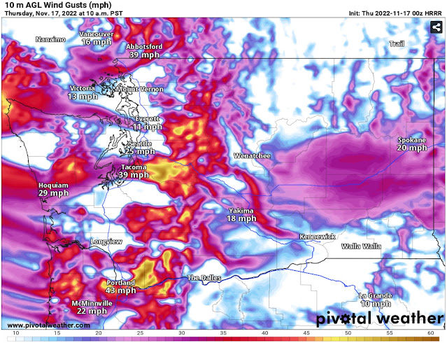
The HRRR forecast for gusts at 10 AM Thursday is below.
Expect gusts in the foothills and Whatcom County to peak at 40-50 mph. Gusts in the Central Sound from Seattle to South Tacoma will reach up to 30-40 mph, strongest from approximately 8-11 AM.
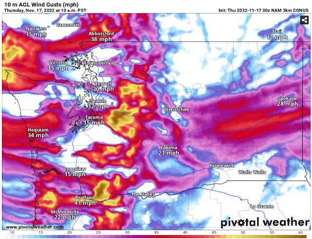
The NAM high-resolution forecast is also below.
The NAM agrees with the HRRR for winds in the foothills, Whatcom County, and Central Sound, while increasing winds to 30-40 mph for Grays Harbor County and the Central Coast.
Additionally, the Portland area and S. WA Coast/N. OR Coast will gust 30-40 mph, with areas near the Columbia River Gorge reaching 40-50 mph. The high-resolution models are quite similar with these winds in most of the vulnerable regions, so there’s a good bet these predictions will be accurate.
Across the region, isolated power outages and tree damage are possible, especially since these winds aren’t from the typical direction. Be prepared!
These winds will also bring significantly drier conditions than normal. The humidity forecast from the HRRR at 6 PM Thursday is below.
Notice low relative humidity in the Central Sound is in the 30-40% range, potentially lower. This will also bring dewpoints of 5-15º, quite dry for this time of year (but decreasing the potential of roadway icing on Friday morning).
Morning lows through Sunday will continue to be in the mid 20s to low 30s, with areas of freezing fog and low clouds.
A big change is ahead by Monday, with stormy weather returning, so stay tuned.


No comments:
Post a Comment