No FastCast today. Keep reading below for information about a complex storm ahead on
A complex storm is ahead for the Pacific Northwest. Western Washington will be impacted by lowland snow, rain, wind, and heavy mountain snow. So, let's break it down.
Most of this blog will detail the snow, but continue to the bottom for a brief note about gusty winds and rain.
To determine the most likely scenario, we will compare 4 accurate forecast models to gather a consensus. One consensus is already clear: snow will begin from south to north, roughly from 9 AM-12 PM. Snow will changeover to rain from 2-8 PM from Seattle southward and from 9 PM-1 AM from Seattle northward. Sticking snow is most likely north of Seattle and on the Kitsap Peninsula, so that is where the biggest road impacts are expected. The Cascades will also receive 1-2 feet of snow, making mountain pass travel very difficult.
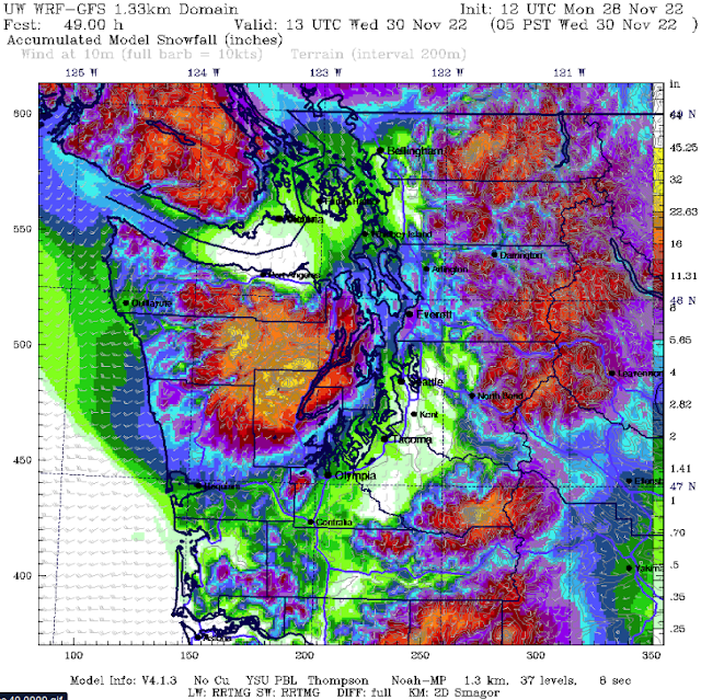
Let's start with the highest-resolution model, the UW model, showing snow through 5 AM Wednesday.
The UW forecast shows that areas from North Seattle to Mount Vernon (including Whidbey Island & the Admiralty Inlet area) will receive 2-8 inches of snow. Areas from Seattle southward will get a dusting to 1 inch of snow. Whatcom & San Juan Counties receive 1-5 inches with this forecast is the Kitsap Peninsula, where 4-12 inches are possible (even more near Hood Canal!). Areas from Olympia to Centralia will get 1-3 inches, and the coastal areas from Westport northward will get 1-6 inches.
Now for the NAM high-resolution forecast, showing snow through 5 AM Wednesday.
The NAM shows the most snow from Seattle to Mount Vernon and from Bellingham into BC, where 2-6 inches are possible. Areas from Seattle south will get a dusting to 1 inch, as will the coast. Areas from Olympia to Kelso will get 0.5-2 inches. The NAM also shows 3-10 inches on the Kitsap Peninsula, most closer to Hood Canal.
Below is the HRRR high-resolution forecast, also showing snow through 5 AM Wednesday.
The HRRR shows the most snow from Shoreline to the Canadian border, with 2-6 inches possible. Areas from Seattle south and on the coast receive a dusting to 1 inch in this forecast. The HRRR gives the Kitsap Peninsula 2-10 inches.
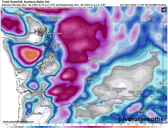
Finally, we'll look at the reliable, albeit lower-resolution European model, showing snow through 4 AM Wednesday.
The European model shows the most snow from Seattle to the Canadian border, with 2-6 inches possible in these areas. Areas from Seattle south receive a dusting to 1 inch, and areas from Olympia to Vancouver, WA and on the coast receive 0.5-2 inches. The Kitsap Peninsula will receive 2-12 inches in the European model forecast, most near Hood Canal.
So, below is the consensus from all the models:
Seattle to the Canadian Border: 2-6 inches
Seattle to Olympia: Dusting-1 inch
Kitsap Peninsula: 2-12 inches
Coast from Westport northward: Dusting to 2 inches
Olympia to Kelso: 0.5-2 inches
After snow ends, expect moderate to heavy rain across the entire region. The European model forecast below shows total precipitation (essentially the amount that will fall into a rain gauge) through 10 PM Wednesday.
Across the area, total precipitation will reach 0.75-1.25 inches. This storm will be a very rainy one on the coast and the Willamette Valley, with those areas receiving 1.5-2.5 inches of rain.
Finally, there will be strong winds from Tuesday evening through early Wednesday morning. Below is the NAM forecast for gusts at 10 PM Tuesday.
Winds will peak across the region from approximately 6 PM Tuesday to 4 AM Wednesday. Winds will gust up to 40-50 mph for the entire region, strongest near the water, on the coast, and north of Everett. These winds will play an interesting part with the snow situation, and will either scour out snow sooner than expected, or create dicey conditions where it is snowing. As always, winds will produce isolated tree damage/power outages, especially if trees are heavy with snow.
The best thing to do is to stay tuned to the latest updates, both on Twitter (top right of blog) and local news stations. I will have another blog Tuesday evening with an update on the overall situation. Stay tuned & stay safe!


No comments:
Post a Comment