FastCast—Monday, Nov. 21 to Friday, Nov. 25:
Rain hasn’t fallen in the past 13 days, tying an all-time November record for Seattle. However, that will change on Tuesday. Our first system in 2 weeks will bring 0.2-0.5 inches for the lowlands, with 0.5-0.75” from Everett northward and 0.8-1” on the coast. Breezy conditions, with gusts of 30-35 mph, are possible around the area on Tuesday. The snow level with this system will remain around 4,500 feet, so accumulations at the passes will only be 2-6 inches. However, with days of cold air prior to this system, it is possible to have higher snow accumulations if the cold air is trapped in the valleys near the passes. Conditions state-wide will dry out for the Thanksgiving travel rush on Wednesday and for Thanksgiving Day. Another round of rain is likely to arrive very late on Thanksgiving, with showers at times through Friday. You’ll notice much more clouds and a change in temperatures. Highs this week will reach the upper 40s to mid 50s, with lows in the upper 30s to low 40s.
—————————————————————
Continue reading the full blog below!
After a record-tying dry spell for November, rain is on its way back to Western Washington. A system will impact the region on Tuesday, bringing rain and high mountain snow.
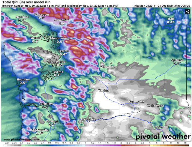
Below is the high-resolution NAM model forecast for rain through Wednesday morning. Expect most rain from early Tuesday through the evening, tapering by night.
Expect 0.2-0.5 inches in the lowlands, with less for the Northern Kitsap Peninsula and between Seattle and Everett. Areas in the foothills and north of Everett will receive 0.4-0.9 inches! The coast will get 0.4-1.2 inches, and the mountains will pick up 1-3 inches.
The European model (below), also showing rain through Wednesday, shows a similar situation.
The European model also shows 0.2-0.5 inches in the lowlands, with less of a rain shadow and less from Everett northward (0.3-0.6”). The European gives the coast and mountains a bit less, around 0.75-1.25 inches. However, this forecast shows a bit more of a Convergence Zone signature between Seattle and Everett. A Convergence Zone would be most likely on Tuesday evening.
Regarding snow, this will be a bit warmer of a system, so snow levels will remain around 4,500-5,000 feet. Below is the NAM forecast for snow accumulation through Wednesday morning.
With a higher snow level, accumulations at the passes will be minimal, likely 2-6 inches. If cold air from the previous few days remains stuck in the valleys around passes, then accumulations at the passes may be higher. A dusting to 2 inches of snow is possible in the higher elevations of NE WA, including a dusting possible around Spokane.
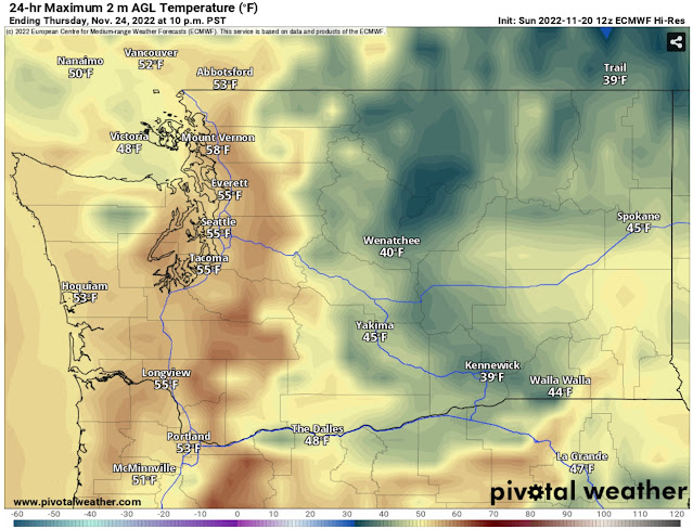
Conditions will dry out by Wednesday, with good conditions expected for travel on Wednesday and Thanksgiving. It will actually be on the balmy side for Thanksgiving, as seen in the European model forecast below.
Highs in the mid to upper 50s are possible! Conditions may be partly to mostly sunny, so a pleasant Thanksgiving is possible for Western Washington, though an inversion layer will keep it much colder for Eastern Washington, with highs only in the upper 30s to mid 40s.
Stay tuned!


No comments:
Post a Comment