FastCast—Saturday, Apr. 15 to Tuesday, Apr. 18:
Showery and cooler than normal conditions are expected to continue across Western Washington through the start of next week. Expect cloudy conditions on Saturday, with highs in the low 50s. Rain arrives late Saturday night to early Sunday morning, continuing (but becoming more showery) through Monday night. Totals will be 0.5-0.8” across the lowlands (isolated higher or lower totals possible), with a rain shadow over the NE Olympic Peninsula and San Juans. The coast will pick up 1-2”, and areas from Olympia southward will pick up 0.75-1”. In the mountains, snow levels will start around 4,000 feet on Sunday, dropping to 1,500 feet by Monday morning. Most passes will receive 0.5-1” of rain, transitioning to 3-6” of snow. Isolated higher totals are possible at Stevens Pass. Back in the lowlands, expect highs through Tuesday in the upper 40s to low 50s, quite unseasonable for April.
—————————————————————
Continue reading the full blog below!
Our cool and showery April will continue in the days ahead. A system will bring more rain on Sunday, with showers continuing through Monday. Below is the European model forecast for total rain through late Monday night.

Across the lowlands, expect 0.5-0.8”, with 0.75-1” from Olympia south, and 1-2” on the coast. Eastern Washington will get 0.1-0.3”, with even more near the Blue Mountains.
Snow levels will start out near 4,000 feet on Sunday, dropping to 1,500 feet by Monday. This means that the Passes will likely start as rain (0.5-1”), then transition to snow. The European model forecast for total snow through Monday night is below.

Expect 3-6” at the Passes, with isolated higher totals, possibly around Stevens Pass. The Coast Ranges of WA & OR could get a dusting to 2” of snow, mainly from Monday onward.
Temperatures continue to be on the cold side. Below is the European model forecast for highs on Sunday.
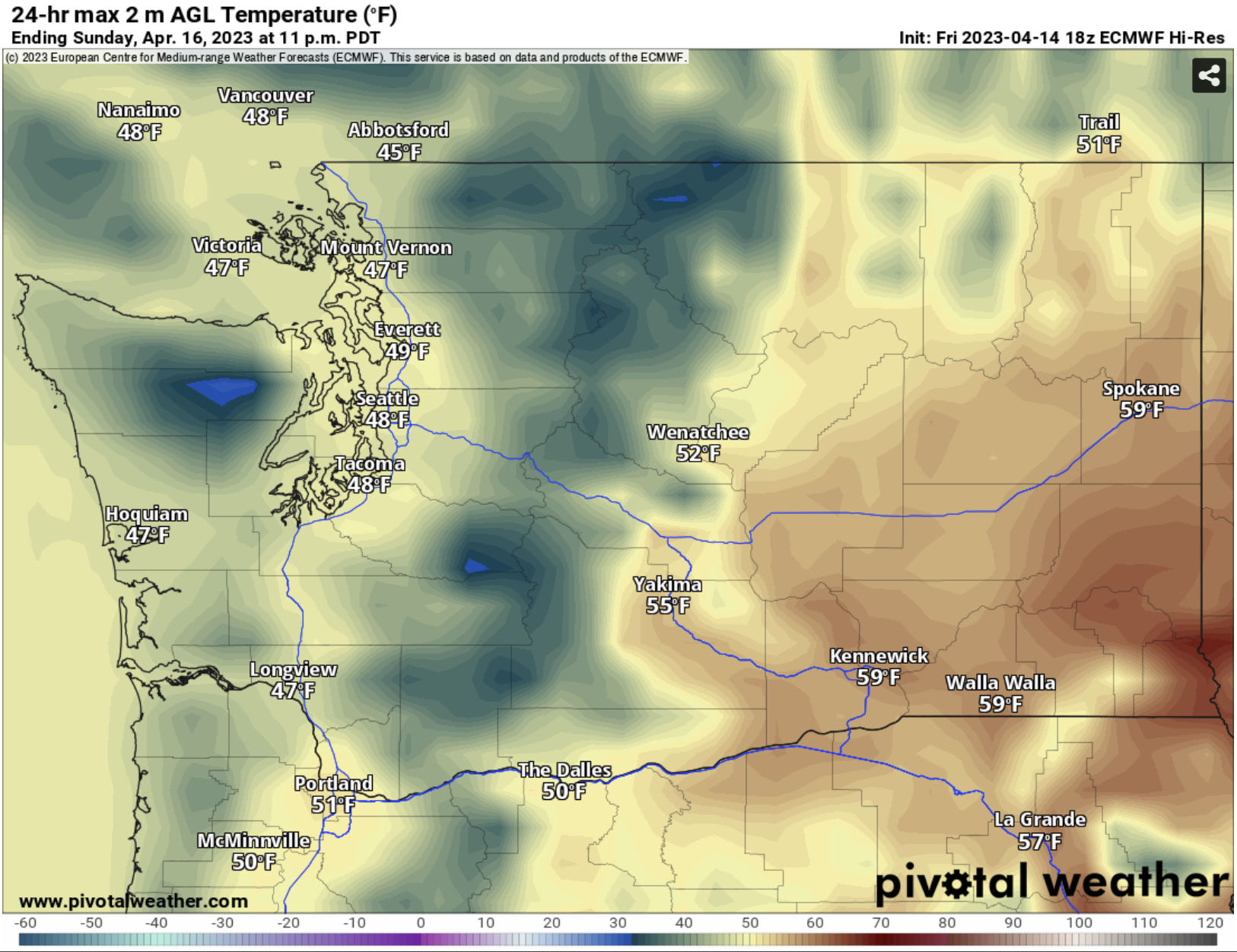
In the lowlands and on the coast, expect highs in the upper 40s to low 50s. These are significantly below average for this time of year. Eastern Washington will be warmer, but still below average, with highs in the mid 50s to low 60s, except colder (low 50s) near the mountains.
Below is the European model forecast showing temperature departure from average at 5 PM Sunday.

Notice that most of Washington & Oregon are 5-15º below average for this time of year.
What about the extended forecast? Let’s take a look at the NWS Climate Prediction Center temperature and precipitation outlooks for April 20-24.
First, the temperature outlook, seen below.

This outlook shows a 50-60% probability of below average temperatures for the entirety of Washington through late April.
Next, the precipitation outlook, also for April 20-24.

This outlook shows a 40-50% probability of above average precipitation through late April for most of Washington. This will continue boosting our reservoir and snowpack ahead of the upcoming El Niño conditions (more on this in a future blog).

No comments:
Post a Comment