FastCast—Saturday, Apr. 29 to Tuesday, May 2:
High temperatures reached record levels across parts of the Northwest on Friday! SeaTac Airport hit a record of 81º, Portland hit 88º, and due to offshore flow, Astoria, Hoquiam, Forks, and Tillamook reached the mid to upper 80s, all records! Another hot day is expected on Saturday, with lowland highs in the mid to upper 70s, with some readings in the low 80s. The coast will be dramatically cooler as marine air moves closer, with highs only in the mid 50s to low 60s. Eastern Washington will be hot, with highs in the upper 70s to upper 80s, with some readings in the low 90s possible. Quite a cooldown is expected for the lowlands on Sunday, with temperatures 15-25º cooler than Saturday, down to the upper 50s to mid 60s, and overcast skies. Similar conditions will continue on Monday, with a chance of showers. By Tuesday, expect temperatures to increase back toward the mid 60s to low 70s. Lows will remain in the upper 40s to low 50s through Tuesday. There is a chance of thunderstorms across the state next week, as an upper level trough will bring showers into the region on multiple days. The extent and placement of thunderstorms is still uncertain, so stay tuned!
———————————————————
Continue reading the full blog below!
What a beautiful day! Friday brought deep blue sky and record high temperatures across the region (more at the end of the blog). Similar conditions are expected on Saturday, so let’s take a look at some forecasts.
First, the HRRR forecast for Saturday’s highs.

The HRRR shows the lowlands reaching the mid to upper 70s, except in the low 70s near the water. Areas around Portland will likely reach the upper 70s to low 80s. Eastern Washington will reach the low 80s to low 90s. The coast is significantly cooler, with highs plummeting to the mid 50s to low 60s.
Now, let’s compare this with the NAM forecast, also for Saturday’s highs.

The NAM is warmer for the lowlands and the coast. This forecast shows highs in the lowlands in the mid to upper 70s, all the way south through Portland. Isolated readings in the low 80s are possible. This agrees with the HRRR for Eastern WA, with highs in the low 80s to near 90º. However, this forecast has warmer temperatures on the coast, in the low to mid 60s.
Remember that the water is COLD, with rivers and lakes in the upper 30s to upper 40s, and Puget Sound & the ocean in the mid to upper 40s.
Western Washington is in for a major cooldown on Sunday. Take a look at the temperature difference from 4 PM Saturday to 4 PM Sunday from the NAM model.
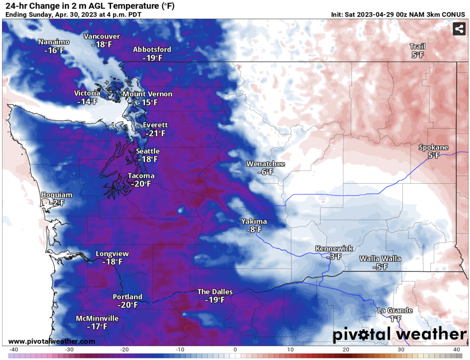
Western Washington, mainly the lowlands, will be significantly cooler. Highs on Sunday will likely be 15-25º below Saturday’s highs from Vancouver BC all the way to the Willamette Valley. Notice cooler temperatures are trying to creep into Eastern Washington as well.
What will temperatures drop to on Sunday? Below is the NAM forecast for Sunday’s highs.

Expect a significant drop west of the Cascades, with the lowlands dropping to the mid 50s to mid 60s. Eastern Washington will remain on the hot side, with highs in the upper 70s to upper 80s.
Forecasts show that due to an upper trough moving down the coast from Sunday to Tuesday (bringing showers to the region) will bring multiple chances of thunderstorms, especially in & east of the Cascades. Stay tuned to future blogs for more on this situation!
Below are some graphics showing highs on Friday. Note the readings in the 80s across the lowlands (hottest near North Bend due to downslope winds) and the incredible highs on the coast due to strong offshore flow, which also brought hot conditions to the Portland metro.


I guess we will take the nice sunny days when we are given them, not going to have them every day yet.
ReplyDelete