FastCast—Monday, May 1 to Wednesday, May 3:
After a spring heat wave with record high temperatures, a much different pattern is in store for the Pacific Northwest. A slow-moving upper level trough will park off the California coast, bringing SE flow (showers moving from SE to NW over the Cascades) through this week. This pattern will increase instability and lead to a prolonged chance of thunderstorms across the region. Storms are most likely in Eastern Washington, Eastern Oregon, and in the mountains. This a chance that storms will move into Western Washington, and this seems most likely from Tuesday to Wednesday, especially in the afternoons and into the night. However, these systems are difficult to predict, bringing lower confidence in the forecast, especially for Western Washington. Remember to keep your eye to the sky and go indoors immediately if you hear thunder. Regarding temperatures, expect highs in the upper 50s to low 60s on Monday and upper 60s to low 70s on Tuesday and Wednesday, with isolated readings in the mid 70s. Expect lows in the upper 40s to low 50s. Temperatures will cool back to the low 60s by Thursday. Stay tuned to the forecasts and be aware of incoming showers!
—————————————————————
Continue reading the full blog below!
An interesting pattern is ahead for the Pacific Northwest, with a slow-moving trough bringing a chance of thunderstorms and instability in the atmosphere across the region.
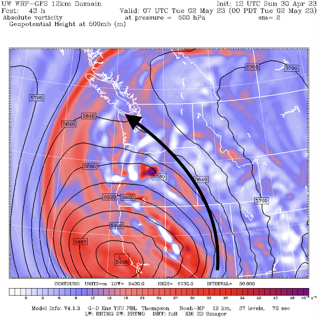
Let’s start with the overall pattern that will bring showers and potential thunderstorms to the region. Below is the UW WRF forecast showing the pattern on Tuesday.
Notice the bright red area with “L” off the Central California coast. That is the trough that will push showers and thunderstorms along the general path of the black arrow I added. This will be the path for thunderstorms in the upcoming week.
One term that will be important to understand in this blog is CAPE (Convective Available Potential Energy), which means the level of instability in the atmosphere, which increases the potential for thunderstorms.
Let’s take a look at CAPE at 6 PM Monday, from the UW WRF forecast.
Notice that most instability on Monday will be confined to far Eastern Washington and parts of SE Oregon and around Idaho.
Let’s take a look at Tuesday evening, also from the UW WRF model.
Instability will increase through the day Tuesday, and according to the UW forecast, there will be widespread instability across Washington. However, this doesn’t necessarily translate to thunderstorms.
As of Sunday night, the best chance of thunderstorms will be Monday in Central WA, with showers moving into the Cascades and potentially Western Washington by Monday afternoon.
More showers will move through the Cascades and lowlands early Tuesday morning.
A good way to see where the strongest showers will be is to look at rain forecasts. Below is the HRRR forecast for rain through 5 PM Tuesday.
Notice the areas of heavier precipitation over Central WA & the Cascades. That is where forecasts show stronger storms, but some storms will be high-based, particularly in the lowlands, meaning that lightning & thunder will occur but little precipitation will reach the ground.
One final aspect of the upcoming forecast is the rebound to warmer temperatures expected for Tuesday and Wednesday. Below is Tuesday’s forecast from the GFS model.
On Tuesday and Wednesday, expect lowland highs in the upper 60s to low 70s, in the low 60s on the coast (low 70s inland), and in the low 70s to low 80s in Eastern WA, warmest north of I-90.
Stay tuned to the blog & my Twitter for the latest information as the thunderstorm threat develops this week. Keep an eye to the sky and go indoors if you hear thunder!


No comments:
Post a Comment