FastCast—Monday, Apr. 17 to Wednesday, Apr. 19:
A persistent upper level trough over the Gulf of Alaska will bring persistent showers and a chance of thunderstorms to the region through Wednesday. Across the lowlands, an additional 0.2-0.5” of rain, with isolated areas under heavier showers getting up to 1” through Wednesday. On the coast, expect 1-2” of rain. At the passes, expect snow levels of 1,000 to 2,500 feet through Wednesday. Expect 6-12 inches of snow at the passes through midweek, with any road impacts limited to nighttime, since daytime temperatures will increase to the upper 30s to low 40s. Lowland temperatures will be quite unseasonable, with highs in the upper 40s to low 50s and lows in the mid to upper 30s. Remember…any showers from Monday to Wednesday could contain lightning, gusty winds, hail, and heavy rain. Be aware!
——————————————————
Continue reading the full blog below!
Consistent showers and a chance of thunderstorms to Western Washington for the first half of the week. Let’s take a look at the total rain forecast from the European model.

This forecast runs from Sunday morning to Tuesday night. Expect 0.7-1.4” in the lowlands, with a rain shadow from Sequim to Everett. Areas from Olympia southward will get 1-1.5”, the coast will get drenched with 2-3.5”, and Eastern WA will pick up 0.1-0.3”.
Now, let’s take a look at a higher-resolution forecast from the NAM model, for the same timeframe as the previous one.
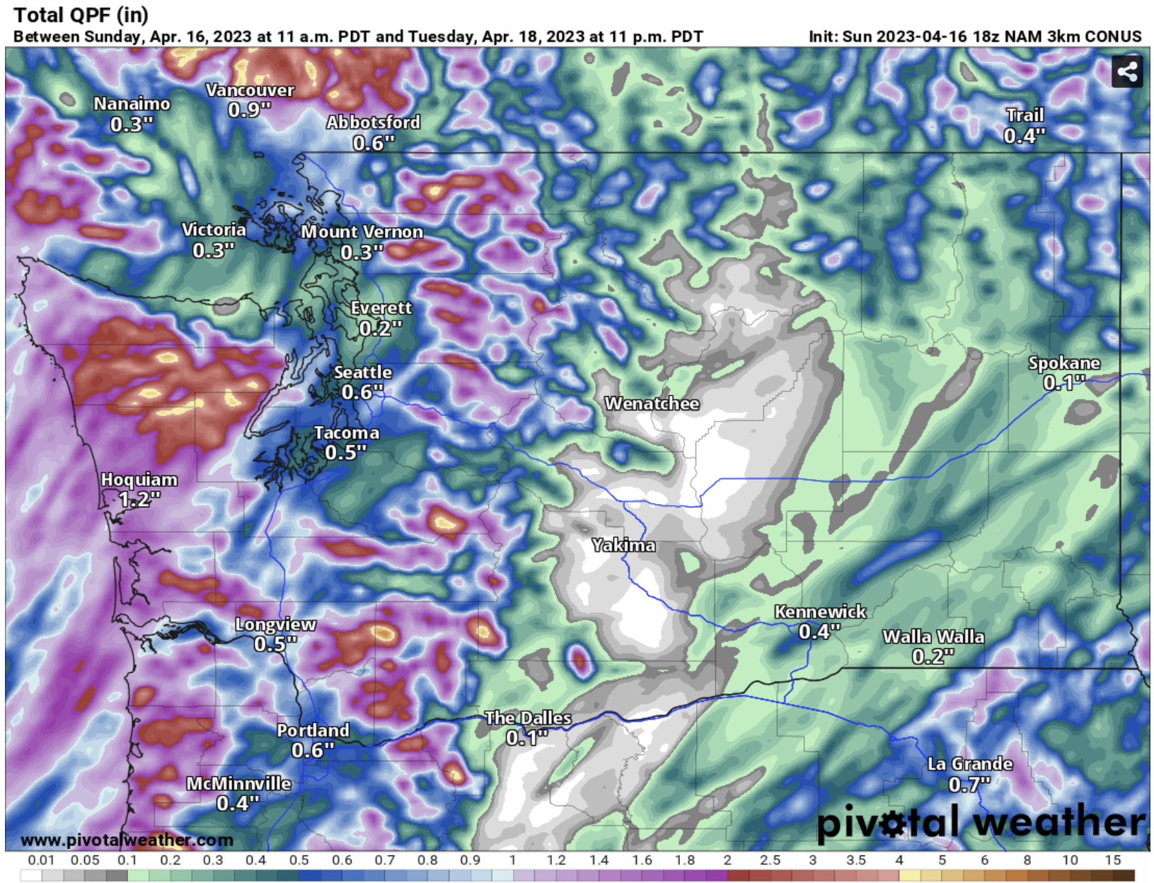
The NAM generally agrees with the European, but shows more sporadic rain totals of 0.2-0.75” in the lowlands, 1-2” on the coast, 0.5-1.25” from Olympia south, and 0-0.4” in Eastern WA.
What about the mountains? Due to the chilly nature of the current pattern, snow levels will remain at 1,000 to 2,500 feet. However, since it is springtime, high temperatures at the passes will reach the upper 30s to low 40s, limiting snow impacts to nighttime. Below is the European model forecast for snow through Wednesday night.

Through the first half of the week, expect 6-12 inches of snow at the passes, 1-4” in the Coast Range, and up to 3 feet in the Olympics. Snow-related driving impacts will be limited to nighttime or very heavy snow showers.
Now for the other element of this week’s weather…a chance of thunderstorms. Let’s take a look at the UW WRF forecast for CAPE (measure of instability, which produces thunderstorms). The first forecast is for Monday evening.

This forecast shows CAPE values of 200-400, decent for Western Washington.
Next, let’s take a look at Tuesday’s CAPE forecast, also from the UW WRF model.

This shows more widespread instability and CAPE values of 200-400 across the region.
Overall, be prepared for heavy showers and a chance of thunderstorms through Wednesday. Any showers could contain lightning, gusty winds, hail, and heavy rain.
One final note for this blog…temperatures are unseasonably low. Let’s take a look at Monday morning’s lows, forecasted by the European model.

Expect chilly lows in the mid to upper 30s. Eastern Washington will drop to the upper 20s to mid 30s from I-90 north, and in the low 30s to low 40s from I-90 south.
High temperatures will also be on the chilly side in the lowlands, as seen in the European model forecast for highs on Tuesday.

Expect unseasonably cold lowland highs in the upper 40s to low 50s. Eastern WA will also be on the cold side, with highs in the upper 40s to mid 50s.

I am enjoying a nice morning at my house this morning, but suppose we are going to be wet this afternoon.
ReplyDelete