FastCast—Sunday, Apr. 23 to Thursday, Apr. 27:
After a warm day on Sunday, with highs in the upper 50s to mid 60s, more rain is in store. Rain will fall from late Saturday night through Sunday morning, and again from Sunday night to Monday morning. Across the lowlands, expect 0.25-0.5”, with isolated higher totals where there are heavier showers. Areas on the coast and from Everett northward will receive 0.5-1.25”. Tuesday will bring drier conditions and decreasing clouds by the evening. Through Tuesday, expect lowland highs in the mid to upper 50s, with lows in the low 40s. Wednesday and Thursday will bring more decreasing clouds, with highs jumping into the upper 60s as a high pressure ridge builds. Lows will remain in the mid to upper 40s. There is potential for even higher temperatures (70º+) by Friday. Stay tuned!
——————————————————
Continue reading the full blog below!
At last…a warmup is ahead for the Pacific Northwest! However, a couple rounds of rain are ahead first.
Let’s take a look at the European model’s forecast for rain through Monday night.
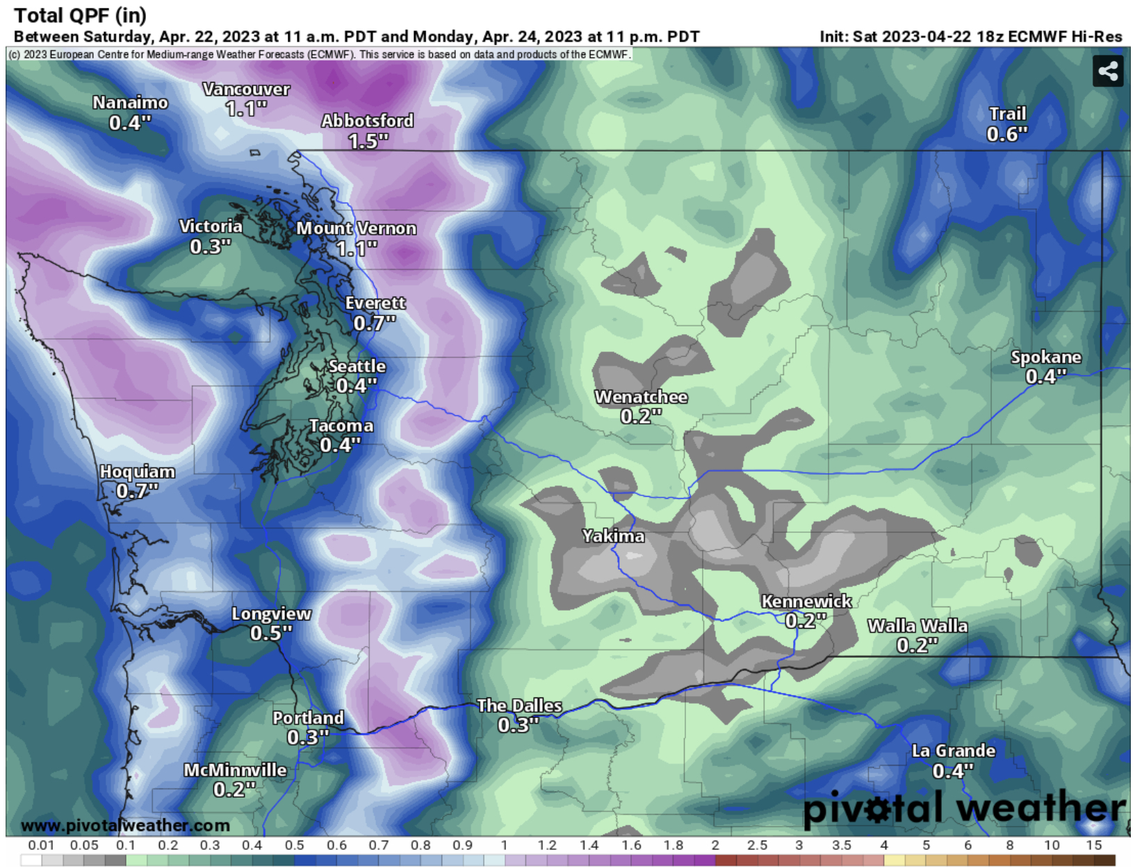
In the lowlands, expect 0.25-0.5” of rain, with 0.5-1.25” on the coast and from Everett northward. Eastern Washington will get 0.1-0.4”, with 0.4-0.6” from Olympia to Portland. Isolated higher totals are possible across the region, especially in isolated areas of the lowlands under heavier showers.
Now for what everyone is wanting to know about…the potential warmup ahead. Let’s take a look at why significantly warmer temperatures are possible. Below is the European model forecast for upper-air patterns across North America.

Inside the yellow box is a developing and strengthening high pressure ridge. The position of this ridge will deflect systems away from the Northwest, bringing warmer and drier weather.
An example of what’s in store is seen below, in the NWS NBM model’s forecast for Thursday’s highs.

By Thursday (possibly Wednesday too), temperatures in the lowlands will reach the mid to upper 60s, except in the low 60s near the water. Eastern Washington will warm into the upper 60s to mid 70s, and areas from Olympia southward will warm to the upper 60s to mid 70s. There is a decent potential for even warmer temperatures from Friday to Saturday, so stay tuned!
What about the extended outlooks? Let’s take a look at the NWS Climate Prediction Center outlooks for April 28 to May 2.
First, temperatures, seen below.

For the first time in months, there is a significant above average signal for the Pacific Northwest. Washington has a 50-70% probability of above average temperatures to end April and start May.
Next, precipitation, seen below.

Also for the first time in awhile, there is a widespread area of below average precipitation across the Northwest. Expect a 40-50% probability of below average precipitation to end April and begin May across the state.
Stay tuned to upcoming blogs, as details about the upcoming “heat” become more certain!

Thank you for the good news about a warm up in the weather.
ReplyDelete