FastCast—Tuesday, Apr. 11 to Friday, Apr. 14:
The atmospheric river is moving out of the region as of Monday night. Totals were from 1-1.9” from Seattle southward, 0-0.9” from Seattle northward, and 2-3” near the mountains and on the coast. Another system is moving in and will bring showers to the region on Tuesday and early Wednesday. Expect rain totals of 0.3-0.7” around the lowlands, with areas of higher totals around Everett, in the Convergence Zone. Snow levels, which were over 6,000 feet due to the atmospheric river, will crash to 1,500 feet by Tuesday night. At the Passes, expect 4-12 inches, highest at Stevens Pass. Additionally, there is a slight chance of thunderstorms across the region on Tuesday, so be prepared when showers move in. From Wednesday to Friday, expect partly to mostly cloudy conditions, with only a slight chance of showers on Thursday evening. In the lowlands, expect highs this week in the low to mid 50s, with lows in the mid to upper 30s.
————————————————————
Continue reading the full blog below!
After an atmospheric river moved through the Pacific Northwest, another system is ahead on Tuesday and early Wednesday. This system will be mainly showery, but will still bring a decent amount of rain. Let’s take a look at the forecast.
Below is the NAM high-resolution forecast for total rain through late Wednesday.
Generally, expect 0.25-0.4 inches of rain across the lowlands, with 0.4-0.75” around Everett in a Convergence Zone. On the coast, expect 0.5-1.5”, most in heavier showers. Eastern Washington will get 0.1-0.75”, with isolated higher totals possible.
Snow levels will crash as this colder system arrives. Below is the NAM forecast for snow through late Wednesday.
At the Passes, expect 6-12”, with the highest totals east of Everett due to a Convergence Zone. The Coast Range will also pick up 1-6” of snow, with highest totals isolated to the highest peaks.
Going into the extended forecast, “spring” isn’t the first word that comes to mind, as temperatures aren’t going to be warming too much. However, more rain is also expected, which will continue to help the water supply and snowpack.
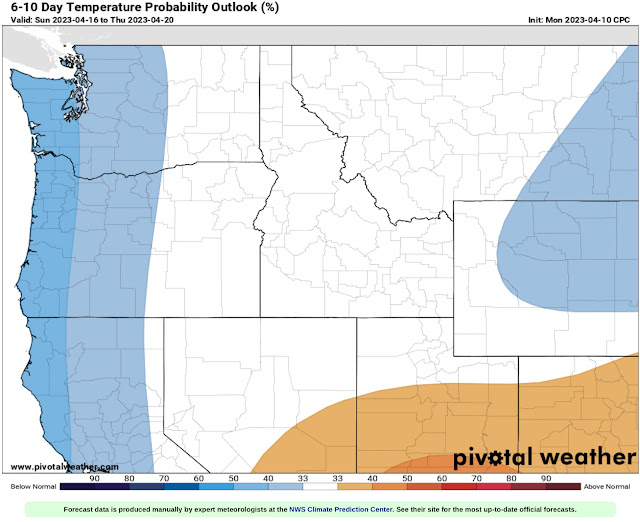
Let’s take a look at the NWS Climate Prediction Center outlooks, starting with the temperature outlook for April 16-20.
Expect a 33-50% probability of below average temperatures, mainly from the Cascades westward. This isn’t too strong of a probability, so more seasonable days are possible.
Now for the precipitation outlook for April 16-20, seen below.
There is a 33-60% probability of above average precipitation for most of the Pacific Northwest, with a 50-60% probability bullseye for Western WA & OR, from about Eugene northward.
Warmer spring weather remains on hold…stay tuned!


This is not the weather report I want to see.
ReplyDelete