FastCast—Sunday, Apr. 9 to Wednesday, Apr. 12:
A significant atmospheric river is ahead for the Pacific Northwest, with steady rain impacting the area from Sunday morning through Monday night, with another system bringing rain on Tuesday. Through Tuesday, expect rain totals of 1-2 inches in the lowlands, with 0.25-1” in the rain shadow (Whidbey Island and the San Juans). Areas in the Cascades (under 6,500 feet), in the foothills, and from Chehalis southward will pick up 2-2.5”. The coast will get 2.5-4”, and isolated areas in the Coast Range and Olympics could get over 4”. In Eastern Washington, expect 0.4-1.25” of rain through Tuesday. Snow levels will rise to 6,500 feet by Sunday night, so all passes will receive rain, though snow levels will crash on Tuesday, dropping to 1,500 feet by Tuesday night. During this time, snow is expected at the passes (stay tuned in future blogs about this). Breezy conditions are expected around the region as well, with gusts of 25-35 mph in the lowlands and 35-40 mph on the coast. Expect highs in the mid 50s on Sunday dropping to the mid to upper 40s by Tuesday, with lows in the low 40s on Sunday, dropping to the mid to upper 30s by Tuesday. Standing water and ponding is expected on area roadways, with rises on area streams and rivers, and moderate flooding on the Skokomish River near Potlatch and Union.
————————————————————
Continue reading the full blog below!
The biggest rain event of 2023 is ahead for the Pacific Northwest, with a significant atmospheric river impacting the region from Sunday through late Monday, followed by more rain in a system on Tuesday, with some showers continuing through early Wednesday.
Below is the UW forecast for water vapor transport (how atmospheric rivers are measured) at 1 PM Sunday.
This atmospheric river will be aimed directly up Puget Sound, so there will be no rain shadow for the metro area. Expect a rain shadow from the Olympics to Southern BC, mainly west of I-5.
Rain totals will be significant. Let’s start with the European model forecast through Tuesday night. This forecast includes the Tuesday system (post-atmospheric river).
In the metro area, expect 1-2” of rain, with 2-2.5” from Chehalis southward and in the Cascades/foothills. Notice the rain shadow north of the Olympics. Additionally, expect 2.5-4” on the coast and 0.4-1.25” in Eastern Washington.
Now for a shorter and higher resolution forecast, let’s take a look at the NAM forecast through early Tuesday morning.
Higher resolution forecasts tend to show higher rain amounts over terrain, since these forecasts can more accurately show terrain features. The NAM agrees with the European in giving 1-2” to the lowlands, though the rain shadow is more pronounced from Everett north and west. This forecast gives the coast and foothills 2-3”, with the Coast Range, Olympics, and Cascades getting 3-5”. Eastern Washington gets 0.3-1.25”, with some areas getting less, especially near the Cascades and in the Palouse.
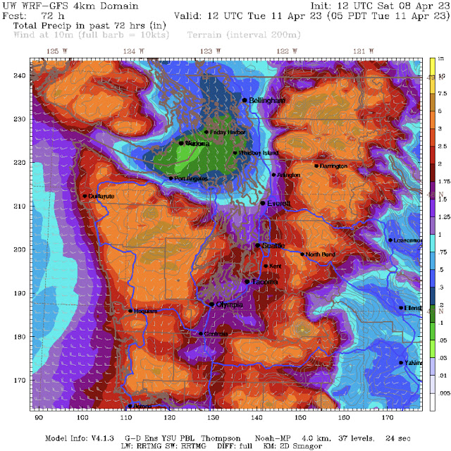
We will look at one more forecast, the UW WRF ultra high resolution model, through
The UW forecast shows by far the highest totals for the entire region, with 1.25-2.5” from Everett southward and quite a pronounced rain shadow to the north. The coast and mountains get significant totals of 3-5”, with isolated totals over 5”. This solution is a bit more unlikely than the others, but is still possible.
There is a slight risk that some of this rainfall may bring urban flooding at short notice (flash flooding), as seen in the Weather Prediction Center Excessive Rainfall Outlook for Sunday.
The marginal risk of excessive rainfall exists for the South Washington Cascades, the Olympics, and the coast & Coast Range from Florence, OR northward.
Finally, due to this atmospheric river bringing more mild subtropical air, snow levels will skyrocket to 6,500 feet by Sunday night, remaining from 4,500-6,500 feet through Monday night. Then, as a colder system arrives on Tuesday, snow levels will drop rapidly to 1,500 feet by Tuesday night. Snow isn’t expected at the passes until Tuesday.
Remember that there is a significant risk of urban flooding, standing water, ponding, and rises in small streams & creeks. Rivers will rise, with bankfull stage possible on the Snoqualmie River and moderate flood stage on the Skokomish River near Potlatch.
Stay safe in all this rain & stay tuned for the next blog by Monday night!


No comments:
Post a Comment