Sunday, August 14, 2022

Next Heat Wave Arrives Midweek

FastCast—Monday, Aug. 15 to Friday, Aug. 19:

A couple cooler days are ahead to start the week before the next brief heat wave begins. Expect mostly sunny conditions on Monday and Tuesday, with highs in the low 80s and lows in the upper 50s. Heat builds on Wednesday and Thursday, with lowland highs reaching the mid 80s to low 90s. Lows will only reach the low to mid 60s. In Eastern Washington, highs will reach the upper 90s to mid 100s yet again through at least Friday. Areas of decreased air quality and wildfire smoke are possible in Eastern Washington due to fires in the area. On the coast, expect highs in the 60s with breezy northerly winds at times. Remember to take necessary heat-related precautions around the state, including staying inside or out of the sun during the hottest times.

——————————————————

Continue reading the full blog below!

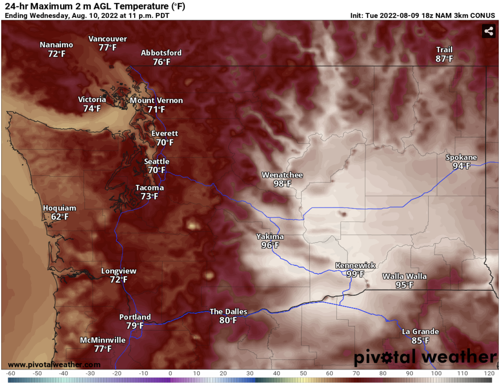
Yet another run at 90 degrees is ahead for parts of Western Washington, with the hottest temperatures expected on Wednesday and Thursday. Before we get there, expect two near-average days on Monday and Tuesday. Monday’s highs are below from the NAM model.


Expect highs on Monday and Tuesday to be in the upper 70s to low 80s in the lowlands, the mid to upper 60s on the coast, and the low to mid 90s in Eastern Washington, except the upper 90s in the Tri Cities area.

The transition to the heat wave can be seen when comparing the UW upper-air forecast for Monday morning to the same forecast for Thursday. Monday morning is below.


On Monday morning, the Pacific Northwest will be between a low in the Gulf of Alaska and a high near Hawaii. 

By Thursday (below), the situation is much different.


By Thursday, high pressure dominates from the Southwest into the Inland Pacific Northwest. A low will be forming offshore from Oregon, but heat will be firmly entrenched over the Pacific Northwest.

Thursday will be the hottest day of this brief heat wave, as seen in the European model forecast below.


Expect Thursday to be quite hot. The lowlands will reach the mid 80s to low 90s, except the mid 90s in the foothills, Olympia area, and the Portland area. The coast will be cool, in the mid 60s to low 70s. Eastern Washington will be scorching once again, with highs in the upper 90s to mid 100s.

Remember to take heat-related precautions, especially if you are doing outdoor activities. 

Above average temperatures will continue for the next couple weeks, as seen in the Pivotal Weather/CPC climate outlook below for August 20-24.


There is a 60-90% chance of above average temperatures over the Pacific Northwest, meaning that it is likely that warm conditions (80+ degree highs) will continue for some time.

Stay tuned for more information about upcoming heat!

Tuesday, August 9, 2022

Area-Wide Chance of Thunderstorms & Much Cooler on Wednesday

 FastCast—Wednesday, Aug. 10 to Saturday, Aug. 13:

An interesting weather situation is ahead, with an area-wide chance of thunderstorms due to monsoonal moisture moving north into the Pacific Northwest. It will also be the coolest day of the week, especially in Western Washington, where highs in the lowlands will only reach the upper 60s to low 70s. Showers will move from south to north from very early Wednesday morning through early afternoon. With high instability (CAPE values) throughout the region, any shower could become a thunderstorm. There is also a chance of severe thunderstorms in Eastern Washington on Wednesday. There is a risk of dry thunderstorms and dry lightning strikes over the west slopes of the Olympics and the entirety of the North Cascades, meaning that there will be an increased risk of wildfires. A Red Flag Warning has been issued for these areas on Wednesday. Total rain will be highly dependent on the locations of showers, but under the showers, expect 0.1-0.3 inches of rain. From Thursday to Saturday, expect highs in the upper 70s to low 80s, with morning clouds and afternoon sun. Continue reading below for more information about thunderstorms on Wednesday! Remember, “when thunder roars, go indoors” and stay inside for at least 30 minutes after you last hear thunder.

——————————————————

Continue reading the full blog below!

Moisture from the Southwest Monsoon will move into the Pacific Northwest on Wednesday, bringing a chance of thunderstorms to the entire region.

The highest instability (CAPE values) will be on the coast and in the Cascades, especially the North Cascades. Eastern Washington will also have a high chance of thunderstorms. Instability on the map doesn’t necessarily mean that storms will be present, but there is a higher opportunity. The UW forecast for CAPE (instability) at 11 AM Wednesday is below.


The highest instability will be on the coast and over the Cascades and Olympics, but in the afternoon. 

Thunderstorms on Wednesday will bring 2 main hazards to the Pacific Northwest. The first is the marginal risk of severe thunderstorms for Eastern Washington, as seen below.


This risk area includes population centers like Spokane, the Tri-Cities, Ellensburg, and Wenatchee. In the risk area, there is a higher chance for strong thunderstorms, 1+” hail, and 58+ mph wind gusts.

Another threat is dry thunderstorms. Because it is summer, it can be harder for rain to reach the ground, so there is no rain to immediately extinguish lightning-started fires. Additionally, thunderstorm outflow winds can cause fires to spread fast. Due to this, a Red Flag Warning has been issued for the areas highlighted in bright red below.

NWS Seattle is warning for a high fire risk on the west slopes of the Olympics and in the North Cascades, and NWS Portland is warning of a high fire risk for the east Coast Range, the entire Willamette Valley, and the west slopes of the Cascades.

Remember that a fire risk exists even if you are outside the Red Flag Warning zones. Any thunderstorm can be a dry thunderstorm, so be vigilant!

Rain will be highly dependent on where showers set up. The UW forecast for rain through 5 PM Wednesday is below.


As explained earlier, the rain will be quite sporadic, with a higher chance near the coast. Generally, expect 0-0.15 inches in the lowlands and up to 0.25-0.3 inches on the coast and in the Olympics. 

One more thing about Wednesday…it will be much cooler than the past few days. The high temperature forecast is below, from the NAM model.


Expect a cool day, with lowland highs reaching the upper 60s to low 70s. The same cannot be said for Eastern Washington, where highs will again reach the mid to upper 90s.

A good way to see weather updates is to follow local meteorologists on Twitter. Michael Snyder (@SeattleWXGuy) is a good one to follow. Also, stay tuned to the radar feature on your weather app. Radar can also be found at radar.weather.gov.

Sunday, August 7, 2022

Brief Heat Wave Continues, Changes Ahead

This is Blog Post #400 on The_Weatherman2 Weather Blog!! Thank you for following along!

FastCast—Monday, Aug. 8 to Friday, Aug. 12:

The short heat wave currently impacting the Pacific Northwest will continue on Monday, with temperatures again reaching the mid 80s to low 90s, as they did on Sunday. The coast will be much cooler, with highs in the low to mid 60s, after reaching the mid to upper 80s on Sunday. It will be different story in Eastern Washington, with temperatures reaching the mid to upper 90s, except the low to mid 100s in the Columbia Basin. Most of Washington state will be impacted by light smoke aloft for the next couple days, with some surface smoke at times in Eastern Washington. A change is ahead from late Tuesday through Wednesday morning. A low pressure system offshore will push showers through Western Washington (stay tuned for updates on the chance of thunderstorms), bringing 0.1-0.2 inches of rain to most of the area. Temperatures will drop to the low to mid 70s in Western Washington and back down to the upper 80s to mid 90s in Eastern Washington. Western Washington will have temperatures rebound with sunnier conditions on Thursday and Friday. Temperatures in the lowlands will reach the low 80s, and will reach the mid 60s on the coast. It will be back to the 90s in Eastern Washington.

—————————————————————————

Continue reading the full blog below!

The brief heat wave will continue on Monday, with another day of highs in the mid 80s to low 90s for most of the lowlands. The NAM model forecast for Monday is below.

This forecast tends to be 2-3 degrees too cool for Western Washington. Generally, expect highs in the lowlands to be in the mid 80s to low 90s, except in the low to mid 60s on the coast. Eastern Washington will be scorching, in the upper 90s to mid 100s. Portland and SW WA will be in the upper 80s to low 90s. 

Most of you probably noticed the increasing haziness in the sky on Sunday. That is due to wildfire smoke from a combination of fires in California, Oregon, and Eastern Washington. The HRRR forecast for smoke aloft on Monday evening is below.


Smoke will be increasing on Monday evening, and a denser plume of smoke (seen in Northern Oregon in this graphic) will move through Western Washington overnight.

By Tuesday afternoon, the effects of continuous southerly flow will be noticeable, as smoke aloft moves through the area in a constant stream because of winds from the south.


By Wednesday evening, haze will be present over most of the state. This will not impact air quality in Western Washington, but some surface smoke will bring decreased air quality at times in Eastern Washington.

A change is ahead…with a low pressure system moving through the region from late Tuesday night through Wednesday morning. This system will bring a decrease in temperatures across Washington, along with a chance of rain and thunderstorms west of the mountains.

The UW forecast below shows expected rain through Wednesday evening.


Notice how to highest totals are in narrow lines. This shows that the rain will likely be confined to stronger showers, not a large area of precipitation (called stratiform rain). Totals of 0.1-0.2 inches are likely in the lowlands, and up to 0.5” in the Olympics.

Now for the interesting part…a chance of thunderstorms from very early Wednesday morning through early afternoon. The UW forecast for CAPE (instability) at 8 AM Wednesday is below.


This forecast shows CAPE values of 400-600 in the lowlands, and 600-800 in the mountains. Stay tuned for updates on the area-wide chance of thunderstorms on Wednesday.

Highs for Sunday are below. It was quite warm for those attending Seafair Sunday! Also, note the big impact that offshore flow has on temperatures at the coast (up to the upper 80s), and the fact that the Portland area was a tad bit hotter than the Columbia Basin.


Next Storm System Hits Western Washington

  8-26 Video Briefing: Next Storm System Hits Western Washington