Saturday, February 10, 2024

Next System Bringing Rain and Mountain Snow to the Northwest

FastCast—Sunday, Feb. 11 to Wednesday, Feb. 14:

After a calm and uneventful week, the next weather system is ahead for the Northwest. Expect rain to begin on Saturday night, continuing through Sunday, before becoming showery on Monday and Tuesday. The lowlands will likely pick up 0.4-0.8”, with isolated areas of higher rain totals. Snow levels will be around 4,000 feet through Sunday, bringing 6-10” of snow to White and Stevens Passes, and with snow levels dropping to 3,000 feet by Monday, Snoqualmie Pass will likely pick up 3-6” of new snow. It will also be breezy on Sunday and Monday, with winds gusting 25-35 mph across the area, except up to 40 mph around Whidbey Island. By Tuesday, conditions dry out and clear up, with partly sunny skies and no rain expected. From Sunday to Tuesday, expect highs in the upper 40s to low 50s, with lows in the upper 30s to low 40s. Cooler conditions are expected from Tuesday onward, with highs in the mid to upper 40s and lows in the low to mid 30s. Stay tuned for updates!

———————————————————

Continue reading the full blog below!

Precipitation is returning to the Northwest after a calm and mostly dry week. Let’s take a look at the forecast!

First, here’s the European model precipitation forecast through Tuesday.


This forecast shows 0.5-1” for the lowlands and the coast, with a rain shadow NE of the Olympic Peninsula. Eastern Washington gets a trace to 0.2” of rain. 

Let’s compare this to the GFS forecast, also showing total rain through Tuesday.


This forecast shows 0.4-0.5” for the lowlands, with 0.5-0.8” from Skagit County northward. This also shows 0.4-0.5” for the southern coast, and 0.6-1.25” from Ocean Shores northward. Eastern Washington (except around Spokane and along the Idaho border) is much drier in this forecast.

Next, let’s take a look at the European model forecast for total snow through Tuesday. Snow levels will start out around 4,000 feet on Sunday, falling to 3,000 feet by Monday.


Expect 4-6” of snow at the passes in this forecast, with higher totals for Paradise, Crystal Mountain, and Mount Baker (6-16”). Parts of Eastern WA, mainly I-90 northward, will get a dusting to 1” of snow, with up to 3” for the northern mountains.

Let’s compare this to the GFS forecast, also showing total snow through Tuesday.


This forecast shows 4-6” at Snoqualmie Pass and 7-10” at the higher passes, with up to 3” around Spokane, and a dusting to 1” for most areas north of I-90. Since the GFS has lower resolution than the European model, this forecast is less likely to occur.

Finally, a breezy period is likely from Sunday to Monday morning. Below is the European model forecast showing peak gusts (zoomed in to Western WA).


The European model shows winds gusting 30-40 mph on the coast and around Everett and Whidbey Island, with gusts up to 30 mph for the rest of the region. 

Let’s compare this to the HRRR high-resolution forecast, which shows a windier scenario (which is generally less likely but still possible).


This forecast shows winds for most of the lowlands gusting 35-45 mph, strongest near the water. The coast will get similar gusts in this scenario. Again, while unlikely, this is still possible.

Stay tuned over the next few days as uncertainty remains regarding the weather over the next week!

Sunday, February 4, 2024

Major California Storm Continues, PNW Remains Calm

 FastCast—Monday, Feb. 5 to Thursday, Feb. 8:

Calm weather will continue for the Pacific Northwest as a major storm persists in California. Cloudy conditions will return to Western Washington on Monday, lasting through the week. Expect a chance of showers, mainly from Monday to Tuesday, early on Wednesday, and late Thursday night. These showers will total 0.2-0.5” of rain across the region. Additionally, expect 2-6” of snow at the passes, scattered throughout the week. In the lowlands, expect seasonable temperatures, with highs in the mid to upper 40s and lows in the mid to upper 30s. Keep reading below for information about the ongoing California storm.

—————————————————————— 

Continue reading the full blog below!

A major storm is ongoing across California, bringing a plethora of significant impacts. Let’s take a look at the forecast, and what’s happened so far.

Below is the high-resolution NAM forecast for total rain in Southern California through late Tuesday.


This forecast shows a staggering 4-7” of rain across the Los Angeles metro area, with up to 10-20” in the Transverse Range Mountains north and west of LA. This will bring damaging flash flooding should this solution verify. 

Let’s compare this to the NWS NBM forecast, also showing rain through late Tuesday.


This forecast also shows 4-6” of rain for the LA metro, with 7-12” for the Transverse Ranges. This is still a staggering amount of rain that will undoubtedly cause major flood concerns.

Lastly, here’s the ever-reliable European model forecast, showing the cause of this major rain and flood event.


This shows the amount of water vapor in the atmosphere, and you can clearly see that the atmospheric river is slamming the Los Angeles metro area and the Transverse Ranges. You really can’t have a more direct hit from an atmospheric river than this. 

Due to the incredibly dangerous flash flooding potential from this atmospheric river, the NWS Weather Prediction Center (WPC) has issued the highest possible excessive rainfall & flash flooding risk for much of Southern California. Below is the risk map for flash flooding.


The entire California coast from San Francisco southward has a moderate risk of flash flooding (40% chance), with an extreme high risk (70% chance) of flash flooding from Point Conception to Orange County, and north into the Transverse Ranges. Saying that the flash flooding potential is dangerous would be an understatement.

Finally, below is a look at 60+ mph wind gusts across Central and Southern California. Numerous locations recorded 80-105 mph gusts, mainly mountain locations. Many coastal and valley locations, including San Francisco, recorded gusts of 60-75 mph. The sheer amount of 60+ mph gusts (even more than what’s seen on this map) likely makes this one of the most significant windstorms in recent history for California. As of the publishing of this blog at 11:00 PM Sunday, there are over 750,000 customers out of power in California.

The maps below show 60+ mph gusts from north to south.


Friday, February 2, 2024

Major Storm Hits California as the Northwest Cools Down

 FastCast—Saturday, Feb. 3 to Wednesday, Feb. 7:

The Northwest is cooling down following an abnormally warm past week. Through the middle of next week, expect lowland highs in the mid 40s to low 50s, with lows in the mid 30s to low 40s. Conditions will be partly to mostly cloudy, with overcast conditions from Monday onward. There’s a chance of showers from Monday evening through Wednesday, but little rain is expected. Keep reading below for a look at the major storm that will be impacting California, plus a look at the forecast for WA (below the California information).

—————————————————————

Continue reading the full blog below!

While mostly cloudy, cool, and relatively benign weather returns to the Pacific Northwest, a major, high-impact storm is heading for California. The storm will consist of a very strong atmospheric river, massive snow totals in the Sierra Nevada, and strong winds. With relatively little going on in the PNW, let’s take a look at the forecast for California.

First, below is the European model forecast for rain through Tuesday morning across Southern California.


This is a staggering amount of rain to fall within 3 days. Most areas from Santa Barbara to San Diego will receive 3-5” of rain, with up to 8” in the mountains around Los Angeles. This will bring widespread flooding, especially on roads and in streams and creeks. River flooding is possible as well. This amount of rain would cause impacts in Seattle, so just imagine what can happen in the LA metro!

Next, let’s take a look at the reason this storm is happening. Below is the European Ensemble forecast for precipitable water (amount of water vapor in the atmopshere) on Sunday.


That is a firehose of moisture pointed right at Central and Southern California. It’s safe to say that it’ll be a very potent atmospheric river.

This atmospheric river won’t just produce rain. It will also bring a huge snowstorm to the Sierra Nevada. Below is the snow forecast through Tuesday morning from the European model.


Wow! Expect staggering amounts of 2-6 FEET of snow through Tuesday. Dinner Pass, which carries I-80 between Sacramento and Reno, will be significantly impacted, with up to 4 feet of snow through Tuesday. Additionally, the mountains of Northern California could receive 1-3 feet of snow, bringing potential impacts to I-5, especially from Medford, OR to Redding.

Finally, let’s take a look at the third facet of this storm…the wind potential. The European model forecast for peak gusts through Tuesday is seen below.


The strongest winds will be confined to the coast, roughly from Point Arena southward. Coastal gusts will range from 50-70 mph, strongest from San Francisco to Point Conception. The Central Valley, Sierra Nevada, and parts of the LA metro will gust 40-50 mph.

Altogether, the major rain, strong winds, and massive snow will create significant weather impacts for a large portion of California. If you or someone you know is in impacted areas, be prepared!

Now, back to the Northwest…temperatures are dropping noticeably from the abnormally warm past week. Below is the NWS NBM forecast for highs on Saturday.


Most areas west of the Cascades will reach the mid 40s to low 50s, with Eastern WA reaching the upper 30s to upper 40s. The coast will be in the low 50s.

Low temperatures will also be noticeably cooler, as seen below in the NWS NBM forecast.


Lows will drop to the mid 30s to low 40s for Western Washington, and the low to mid 30s for the Willamette Valley. Eastern Washington will drop to the low to mid 30s, with the mountains dropping to the low to mid 20s. Morning lows will slowly decrease through the next few days.

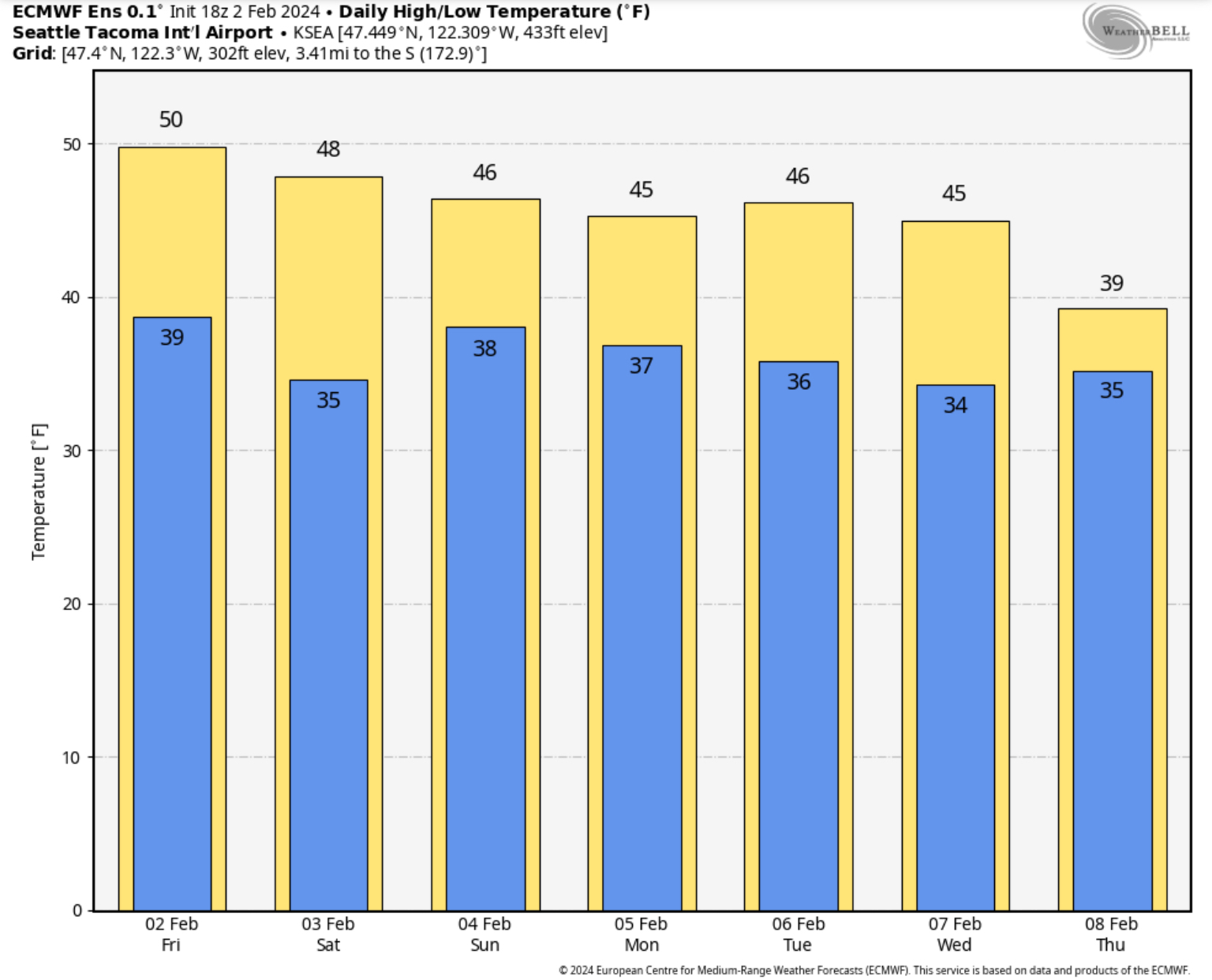
Finally, below is the European Ensemble forecast for temperatures in Seattle over the next few days.


Over the next few days, high temperatures will decrease to the mid 40s, with lows dropping to the mid 30s. These are more seasonable temperatures for February.

Next Storm System Hits Western Washington

  8-26 Video Briefing: Next Storm System Hits Western Washington