
Now, let’s take a look at 2 major weather events going on in the rest of the United States.
Major fires are burning in California, especially the central part of the state. These fires have burned over 700,000 acres as of Saturday.
The reason that fires are raging out of control in California right now is due to over 10,000 lightning strikes last weekend. These strikes were caused by tropical moisture from the remnants of Tropical Storm Fausto in the East Pacific Ocean.
In addition, these were dry lightning strikes. Dry lightning is caused by high-based or dry thunderstorms, basically a thunderstorm without rain. These storms are fire-starting machines.
Take a look at this map of lightning strikes by Tuesday the 18th.
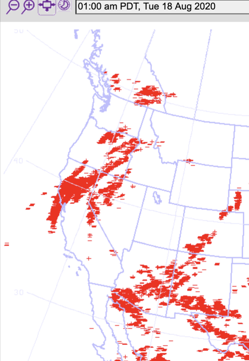
Each lightning strike is a little red line. Look at the areas north of San Francisco. Incredible amounts of lightning.
Many fires were started. The mountains and valleys of north-central California are being ravaged by deadly fires right now.

In particular, the LNU Lightning Complex Fire has burned an incredible 314,000 acres, and the SCU Lightning Complex Fire has burned 292,000 acres. These fires are north (LNU) and south (SCU) of the Bay Area. Here are some photos from weather.com of the fires.


Incredible devastation, especially in Napa Valley and near Vacaville.
Another major hazard is unfolding due to these fires...widespread smoke. Take a look at this map from airnow.gov showing the current smoke plumes around the US. (Darker=thicker).

Smoke from California/other Western US fires stretches to the east coast. All the way across the United States. I don’t recall seeing such a widespread smoke event in a very long time. California is ground zero, with thick smoke stretching all the way north to Saskatchewan, south to New Mexico, and east to Missouri. Incredible.
This picture was sent to me by a relative in Boise, Idaho, on Saturday morning.

Thick, impactful smoke 450 miles NE of the California fires. Smoke is so thick in the Boise area that temperatures have been pushed down a few degrees due to lack of sunlight. This is very hazardous smoke that is rapidly degrading air quality over much of the Western US. Luckily, Western Washington has not, and will not be impacted by this smoke in the foreseeable future. (Should that change, I’ll have a blog).
There is also another US weather hazard. There is now a decent chance that 2 hurricanes could be in the Gulf of Mexico at the same time.
Tropical Storm Marco (below) is just under hurricane strength, with winds of 65 mph. Marco is currently located between Cuba and Mexico’s Yucatán Peninsula. Currently, Hurricane Watches are in effect for Southern Louisiana.

Marco will make landfall Monday afternoon as a Category 1 hurricane (85 mph) near the Mississippi Delta. This will have damaging impacts for all of Southern Louisiana (including New Orleans). However...within 48 hours, another Category 1 hurricane will make landfall in the same area.
Tropical Storm Laura (below) is currently a 50 mph storm over the Dominican Republic. It will move almost directly over the length of Cuba, and could scrape the Florida Keys before emerging into the Gulf of Mexico and becoming a Category 1 hurricane.

Where will Laura make landfall? You guessed it. Southern Louisiana, on Wednesday afternoon, 2 days after Marco does the same thing. Laura will be an 85 mph, Category 1 hurricane. That’s the exact same strength as Marco.
It is rare for 2 hurricanes to make landfall in the same area in the same year, but it’s incredibly rare for those storms to make landfall within 60 MILES of each other. This could be a major disaster for Southern Louisiana, with a damaging one-two punch of hurricanes. For the latest information and coverage, I recommend The Weather Channel (weather.com).
As you can see, there is a lot of wild weather happening around the United States, but not here in Washington. Enjoy our sunny and warm weather as we slowly cool towards fall!

No comments:
Post a Comment