Wednesday, June 30, 2021

Clouds Arrive & Heat Moves East, Above Average Temperatures to Continue

After the hottest conditions in Western Washington history, marine air and clouds have finally arrived in the Central Sound area! Wednesday morning's clouds are the first to cover the area in the last 7 days.


I stepped outside and it felt so refreshing...at the time of this photo it was 64 degrees, a whopping 27 degrees cooler than Monday at the same time (91F).

The marine layer will bring substantial cooling to Western Washington on Wednesday and again on Thursday, when an even stronger marine push is likely. Below is a forecast for Seattle from NWS Seattle showing what to expect through next Monday.


The "coolest" days, with highs in the low 80s, are likely through Thursday. As we approach the weekend of the Fourth, temperatures warm again. Highs will peak from Friday to Sunday, with temperatures of 85-90 degrees across the area.

Even the upper 80s are a major relief from the incredible temperatures we experienced over the past few days. Now, the heat has moved east into the Inland Northwest. Below are Monday's highs in Eastern Washington.


Yuck! Widespread highs of 105-120 degrees. Richland Airport (just west of Kennewick) possibly tied the all-time state record of 118 degrees. More information about state records should be available soon. Many records were set in Eastern Washington yesterday, and the heat isn't going away, it'll just be slightly less intense, with almost all areas still over 100 degrees.

However, we are not done with the hotter than normal conditions. As local meteorologist Joe Boomgard-Zagrodnik wrote on Twitter, there is still very warm air aloft. 


The graphic in the tweet shows air at 5,000 ft. being approximately 40 degrees Celsius, or 104 degrees Fahrenheit. As Boomgard-Zagrodnik writes, there is nothing to change to a cooler pattern, and with the very warm air just above the surface, above average temperatures will continue.

The 6-10 day temperature graphic from the NWS Climate Prediction Center for July 5th-9th shows a 65-70% chance of above average temperatures in Washington.


The entire West will have much above average temperatures. This will continue through the extended period, likely through the summer.

Below is the Federal Way forecast from Weather Underground through July 4th.


Expect highs of 78-80F on Wednesday & Thursday, warming to 80-86F from Friday to Sunday. Lows through the next 5 days will be in the upper 50s to low 60s.

Enjoy the much cooler temperatures in Western Washington!

Monday, June 28, 2021

Extreme Heat Day 3: Hottest Day Ever, Relief Underway

Monday, June 28th, 2021 will be one of the most remembered days in Pacific Northwest weather history. It was the hottest day ever across the western parts of Washington and Oregon, with many all-time records being set.

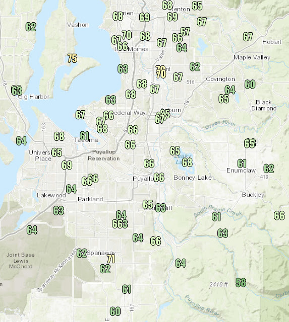
Below are Monday’s record-breaking highs in the South/Central Puget Sound area.


Just incredible. Highs ranged from 100-105 degrees where the Sound breeze caused some cooling to 105-115 degrees away from the water’s influence, easily the hottest temperatures ever in most areas.

Over the North/Central Sound, marine influence had a lesser presence, and nearly all temperatures ranged from 103-113 degrees, with a few upper 90s to low 100s near the Sound. Highs were 105-110 degrees on the Kitsap Peninsula.

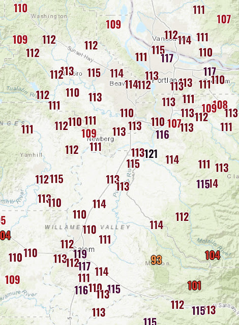
Because we can’t get enough of these incredible temperatures…below are the astounding temperatures in the Willamette Valley on Monday.


Portland and Salem both hit 117 degrees, setting a new record and tying the all-time record…for Las Vegas. How incredible is that?!?

Some all-time records set on Monday include:

Seattle (SeaTac): 108°; Olympia: 109°; Bremerton: 110°; Forks (Quillayute): 109°; Portland & Salem: 117°

Additionally…Dallesport, WA (across the Columbia River from The Dalles, OR) hit an incredible 118 degrees, which if verified would tie the Washington State all-time record high (118°, Ice Harbor Dam). 


However, this record may not stand for long, as temperatures in the 115-120 degree range are likely in Eastern Washington on Tuesday. The poor residents of Eastern WA are now under an Excessive Heat Warning until July 4th…6 more days.

Thankfully, relief is coming to Western Washington as the thermal trough moves east. The map below, as of 9:30 PM Monday, shows cooler marine air bringing down temperatures in Thurston County and SW Pierce County.


The coast is cool, down in the 60s. The 70s-low 80s have made it to the Olympia area, and 60s have made it to Shelton. Further inland, the Tacoma/Federal Way area is slowly dropping below 90 degrees. Urban heat islands, such as South Tacoma, the Greater Seattle area, and the valleys are still in the 90s, and will be slower to cool down. 

Monday night lows will drop to the mid-60s, still warm for Western Washington at night, but 5-7 degrees cooler than the previous nights.

Below is the Puyallup forecast from Weather Underground.


The main story is that well above average temperatures are likely for the rest of this week. Be sure to subtract 2-5 degrees outside the valleys & near water. Onshore flow will keep temperatures from getting above 95 degrees, but multiple days above 85 degrees are likely, considered “hot” weather for Western Washington. 

Because of the recent extreme heat, photochemical reactions were triggered in the atmosphere that has produced hazy skies (smog) over the past few days. 

This picture, taken by Gunner H., looking northwest from Bonney Lake at sunset on Monday gives an excellent visual of haze in the atmosphere.


This has brought air quality levels to moderate across the area. Not a huge hazard, and should get better with marine air.

We have made it through the hottest weather in Western Washington history! At least 10 days of temperatures above 80 degrees are ahead, with the hottest day on Tuesday (90-93 degrees). The Excessive Heat Warning remains in effect until 11 PM Tuesday. 

This heat wave will remain in the memories of Pacific Northwest residents for many years. Now…the attention turns to Eastern Washington, where the state’s all-time record may be broken on Tuesday.

Sunday, June 27, 2021

Extreme Heat Day 2: Triple Digits Continue, History-Making Highs on Monday

Update 9:45 AM Monday: Due to the extreme temperatures, dry conditions, and dry downslope winds, a Red Flag Warning is in effect through 8 PM Monday. It is posted below.


——————————————————————

Original Blog: Posted 9:30 PM Sunday

Sunday was the second day in a row of very hot temperatures across the Pacific Northwest. Below are high temperatures for the Central Sound area.


Highs of 100-105+ degrees were observed across most of the area. 

Notice how not all areas reached 100 degrees. Many areas hit triple digits, except for two…Tacoma and Federal Way.

While these two areas were close to 100 (generally 95-99°), the forecast of 100-105 degrees was too high. Why? North/northwest winds off Puget Sound. Even though these winds were relatively weak (10-20 mph), their origin over the Sound allowed for a few degrees of “cooling” in these areas.

However…it will all change on Monday, when the hottest temperatures ever recorded in the Puget Sound area are likely. 

This will happen for two reasons. The first is the thermal trough, and the second is the warming downslope winds, which will be influenced by the thermal trough.

First off…what is a thermal trough? Basically, it is low pressure generated by sinking hot air in the atmosphere, which forms low pressure. This is common in the Desert Southwest, but is rare for the Pacific Northwest.

In the UW forecast below for 5 PM Monday, the thermal trough is outlined in the rectangle.


Since the thermal trough is centered over the I-5 corridor, we will be cut off from any cooling air, and this thermal trough will draw hot easterly winds out of the Cascades, further warming the area.

Now the big question…how hot will it get? Below is the forecast for the area.

Monday:

Valley: 110-115°

Non-valley: 111-116°

The extreme nature of these temperatures is beyond anything ever recorded in Western Washington. To put it in perspective, the average high temperature for June 28th in Seattle is 74 degrees. The forecast high is 110 degrees, 36 degrees above average. The departure from average will make tomorrow the highest above average Seattle has ever been (previously 29° in April 2016’s heat wave). Additionally, Sunday night’s forecast low is 1 degree warmer than the average high. That is unheard of around here.

Then…after we roast in unprecedented temperatures, a large temperature drop will occur, due to the thermal trough moving across the Cascades, opening the door to cooler ocean air.

Below is a temperature profile for Puyallup from 4 PM Monday to 5 AM Tuesday, from the National Weather Service.


Temperatures drop from 112 to 68, 44 degrees, in 12 hours. Because of this marine influence, Tuesday will have highs in the low to mid 90s, hot still but nearly 20 degrees cooler than Monday.

Please continue to practice heat safety measures on Monday. That’s when you need to protect yourself the most. The temperatures in the forecast are historic, and call for us to protect ourselves against them. Please stay safe!

Monday will have a high HeatRisk (below) across Western Washington, with historic highs of 110-115 degrees.


All-time records will be set on Monday, and likely not broken for many years. I bet we will be talking about Monday’s temperatures for a long time.

One final note…due to the expected 90-95 degree temperatures on Tuesday, NWS Seattle has extended the Excessive Heat Warning through 11 PM Tuesday. The updated alert is below. 


Saturday, June 26, 2021

Extreme Heat Day 1: Triple Digits & Very High Dewpoints, Hotter Weather Ahead

Updated 9 AM Sunday with new Excessive Heat Warning & updated temperature forecasts

—————————————————————

The first day of the ongoing extreme heat wave is in the books. Temperatures were generally 1 to 4 degrees hotter than forecasts indicated. Saturday’s highs are below.


Temperatures ranged from the 90s by the water to 100-105+ inland. One particular temperature to notice is the 102 degree reading at Sea-Tac Airport. Saturday set the Seattle record for hottest June day (previously 96° in 2017) and became the 2nd hottest day ever recorded for the city. It was also the 3rd 100+ degree day in Seattle history.

Portland also set its new all-time record of 108 degrees today, breaking the old record of 107. This new record will likely be broken twice more in this heat wave.

Another aspect of Saturday’s weather were the muggy conditions and very high dewpoints. Record dewpoints of 68-75 degrees were recorded around the area. Some of these readings were reminiscent of the Eastern US. Expect dewpoints of 59-68 degrees through Monday. It’ll feel 2-5 degrees warmer than the actual temperature at times due to these dewpoints.

Looking ahead, the Excessive Heat Warning is in effect through 9 PM Monday. This important and strongly worded alert is below.


With temperatures of 110+ degrees likely on Monday, the newest addition is to mention temperatures up to 115 degrees for Western WA.

Nightly lows are quite warm, with all-time high nighttime temperatures expected  on Saturday and Sunday nights. Lows will only reach 70-78 degrees, breaking the all time record of 71 degrees. Friday night’s lows are below, and they will seem “cool” compared to the upcoming lows.


As for high temperatures, the forecast just keeps getting hotter. In fact, Saturday’s forecast ended up being a few degrees too low, a potentially concerning trend if it keeps up for Sunday & Monday. Below are forecast temperatures for the valley & non-valley areas.

Sunday:

Valley: 104-110°

Non-valley: 102-108°

Monday:

Valley: 111-115°

Non-valley: 112-116°

Not only are these temperatures very extreme for our area, they are 2-12 degrees above all-time records, so there is no climatological comparison to them. All-time records will be shattered multiple days in a row.

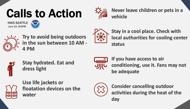
With truly unprecedented temperatures likely, it is imperative that heat safety is the top priority. Below are two informative graphics from the National Weather Service showing heat safety and heat illness signs.


(I advise not being in the sun from 9 AM to 7 PM, in addition to the NWS recommendations)


These are important safety & medical tips that will save lives if implemented. Another good idea is to close your blinds/curtains before the sun hits them. This can help to keep a room cooler for a longer period of time.

Below is Sunday’s HeatRisk for Western Washington. Most of the area is under a high to very high risk.


Remember the warming downslope winds we talked about yesterday? Those didn’t really play a part on Saturday, and temperatures still got over 100 degrees. These winds will become more present on Sunday but especially Monday, and temperatures will be warmer as a result, especially near the Cascade foothills.

We are living through what is likely one of the most extreme and historic weather events in Pacific Northwest history. Some of the hottest days ever recorded in this area are ahead.


Friday, June 25, 2021

Unprecedented Heat Wave Begins Saturday, 110+ Degrees Possible on Monday

We are approaching the start of what will likely be the most unprecedented heat wave in Pacific Northwest history. Many daily, monthly, and all-time records will be broken, and many residents will experience the hottest temperatures they’ve ever seen in Western Washington.

Because of the unprecedented nature of this heat wave, an Excessive Heat Warning is in effect until 9 PM Monday.


The only new addition is the potential for 110+ degrees on Sunday and Monday, but most likely Monday.

Let’s use a similar forecast as the one we used in the last blog, showing temperatures in valley and non-valley locations. These are collected from 7+ forecasts.

Saturday:

Valley: 97-103°

Non-valley: 95-100°

Sunday:

Valley: 105-110°

Non-valley: 102-108°

Monday:

Valley: 108-115°

Non-valley: 106-113°

Temperatures of 110+ degrees are possible on Monday. Confidence in these 110+ degree temperatures is increasing. These are extraordinary temperatures for Western Washington, so high that we don’t have anything to compare them to. Stay tuned, as more information about this will become clear soon.

Also, it may be slightly cooler near the water and slightly hotter near the foothills and in mountain valleys. If you want to truly beat the heat, head out toward the Strait of Juan de Fuca, the San Juan Islands, or the ocean beaches. Temperatures at these locations will be in the 80s-low 90s.

The graphic below from NWS Seattle shows some records for selected cities and the forecast, as well as Sunday & Monday’s HeatRisk.


It looks quite likely that Seattle’s all time record will be broken, not just for high temperature (103°), but also for highest nighttime low (71°). 

Friday’s highs are below, many in the mid to upper 80s. Add 10-15 degrees Saturday and another 5-15 degrees (depending on location) for Sunday and Monday.


Also, the first of many all time records was broken today, with Port Angeles soaring to 95 degrees due to a warm downslope wind, something Puget Sound area residents will become familiar with soon.

When air flows down a mountain slope, it is compressed and warms the surrounding terrain. In our case, warm easterly winds will descend the Cascades. 


This warmed air, which originated in the Desert Southwest, will raise temperatures to 105-110 degrees on Sunday and 110-115 degrees on Monday. Sunday and Monday will be incredibly hot, likely the two hottest days in Seattle history.

These hot days will be accompanied by very warm nights, possibly the warmest nights ever in the Puget Sound area, with lows of 65-77 degrees from Friday night to Monday night.

Additionally, recent rain and increased vegetation in our area will combine with hot temperatures to create increased evapotranspiration (water evaporating), which will increase dew points into the 60s. It won’t feel “muggy” like on cloudy days, but the heat won’t be as “dry” as normal. Increased dew points will make the temperature feel 1-3 degrees warmer than it actually is. 

The most important thing to do in this heat wave is to stay safe. Below are safety tips from NWS Seattle for what to do during this heat wave.


As always, there is also an increased risk of fires due to the heat. Below are more tips from NWS Seattle about how to prevent wildfires.


Although these safety tips might seem repetitive, they are very important. Take every effort to stay safe & hydrated, and take advantage of being in an air-conditioned place if you can.

Expect high temperatures of 95 to 102 degrees on Saturday. A moderate HeatRisk is expected for most of the area.


Thursday, June 24, 2021

Update: Excessive Heat Warning Issued, All-Time Records Likely

Thursday was likely the coolest day for the next 10+ days. Below are Thursday’s high temperatures, mainly in the low 80s around the area.


Now, take these temperatures and add 20-25 degrees, and you have Sunday & Monday’s temperatures.

Due to the upcoming heat, the Excessive Heat Watch has been upgraded to an Excessive Heat Warning. This is the highest type of heat alert. 


It is in effect from 2 PM Friday to 1 PM Monday. Excessive heat is very dangerous, and it should be taken seriously. The National Weather Service has done a good job of portraying the dangers of this heat wave.

Below are likely temperatures for the valley and non-valley areas from Friday to Monday. I have compiled these from 5-8 forecasts.

Friday: 

Valley: 88-92°

Non-valley: 86-90°

Saturday:

Valley: 97-103°

Non-valley: 95-100°

Sunday:

Valley: 105-110°

Non-valley: 102-108°

Monday:

Valley: 105-110°

Non-valley: 103-110°

For many residents, these will be the hottest temperatures they’ve experienced here. As you can see, Sunday and Monday will be the hottest days. All time records will likely be broken across the area, especially Seattle southward, where it will be the hottest. Take 2-5 degrees off these temperatures near Puget Sound.

Low temperatures will also be very warm, and the warmest night ever is likely for the Puget Sound area on Sunday night. Expect low temperatures of 65-75° from Friday night to Monday night. This will likely break the all time record high minimum temperature of 71°.

Before we get to all-time records, let’s take a look at NWS Seattle’s probability forecast.


These charts show the high confidence for very hot temperatures in the coming days. Confidence is lowest for Monday, but expect that to verify soon.

Now, a quick look below at daily, monthly, and all-time records for Western Washington. The chart below from NWS Seattle shows records for selected cities.


Many of these records will be broken, some by large margins, during this heat wave.
One notable tidbit: Seattle’s official observing station (Sea-Tac Airport) has a forecast high temperature of over 103°, so Seattle will likely join Portland and Olympia in breaking their all-time record high.

I mentioned in an earlier blog that only 34% of Seattle area homeowners have air conditioning. Because of this, it is good to have some tips on how to keep your house/apartment cool without air conditioning. This informative graphic from NWS Seattle shows some of these tips.


Try your best to stay safe & stay cool! Another good way to look at the risk for heat is from the new NWS HeatRisk product. For the next few blogs, we’ll look at the next day’s HeatRisk. But first, below is an explanation of the HeatRisk scale.


Click here to find HeatRisk for the next 7 days in Western Washington.

Below is the HeatRisk forecast for Friday. Expect a Moderate risk for most of the region.


One more thing…is “relief” in sight? Short answer: relief from extreme temperatures comes by Monday, but temps remain elevated for awhile. Marine air moving in late Monday will drop temperatures to the range of 85-90 degrees, but highs likely remain above 85 degrees through at least July 5th.

Many people in Western Washington consider 85°+ as “warm” weather, so this will be a long-duration and potentially dangerous hot spell. Make sure you are taking every chance to stay cool and stay safe. 


Wednesday, June 23, 2021

Extreme Heat Update: 100+ Degrees Likely This Weekend

It is now likely that the Seattle metro area will experience temperatures of 100+ degrees at times this weekend and possibly on Monday. 

The Excessive Heat Watch will go into effect at 2 PM Friday until 9 PM Monday. The alert is below.


This is a very strongly worded alert, and for good reason. These will likely be our area's warmest temperatures in the last decade, with Portland and Eastern Washington possibly breaking all time records, and Seattle on the cusp of doing the same.

One thing that was not covered in the last blog post...why is this heat wave happening? Basically, it is due to a massive high pressure ridge, one of the strongest ever in our region. This ridge is created due to a West Pacific tropical disturbance creating waves in the jet stream, causing this ridge. The UW forecast model below shows the incredible ridge over the Pacific Northwest at 5 PM Sunday, near the peak of the heat wave.


The ridge is so large that it effectively deflects all other weather and puts us under a "heat dome" pattern, similar to what caused the very hot conditions in the Southwest recently. The Pacific Northwest is experiencing record heat because this heat dome is centered over our area, something that is quite abnormal.

Let's time things out for the upcoming days. This helpful timeline graphic from NWS Seattle shows what to expect each day and the impact of that day's weather. (Click to enlarge).

A single forecast (like the Weather Underground forecast I normally use) will not be accurate in this situation, since all forecasts are slightly different. The best idea is to take all the possibilities and average them, which is what's shown in the NWS Seattle graphics below, which show the highest possible high temp, lowest possible high temp, and the average.

Saturday:


Sunday:


Monday:


These are very warm temperatures, to say the least. 
Some forecasts show temperatures of 105+ degrees, mainly on Sunday and Monday. These predictions, while crazy, can't be counted out. Seemingly extreme values are still on the table at this point. More certainty on exact temperatures will become clear in the coming days.

The most important thing to do is stay safe! If you can be in an air-conditioned space, take advantage of that opportunity. Below are some very helpful tips from NWS Seattle about beating the heat safely.


In short, this is a dangerous and unprecedented heat wave for the Pacific Northwest, on both sides of the Cascades.

Renowned Pacific Northwest meteorologist & UW professor Cliff Mass said on his blog today that "it is essentially certain that the Willamette Valley and western Washington from Seattle southward will have a historical heatwave, one beyond the experience of many residents."  

Strong words from an experienced professional.

Stay tuned to this blog for further updates. I will do a daily update each evening until this heat wave is over.


Tuesday, June 22, 2021

Major Heat Wave Ahead: What You Need To Know

A major, record breaking heat wave is ahead for the Pacific Northwest. Temperatures of 95-100 degrees are likely for King & Pierce Counties, and all time records are in jeopardy in Portland & Eastern Washington.

Let’s start with the forecast for the next two days, before the heat builds. This is from Weather Underground for Puyallup.

Subtract a couple degrees outside the valley. Wednesday will possibly start cloudy and will be the “coolest” day for the foreseeable future. Thursday will be a few degrees warmer, with less clouds.

Now…we will break down the upcoming major heat wave. 

To start, an Excessive Heat Watch is in effect from 2 PM Friday to 5 PM Monday. The alert is below.

Wow. This is a lot to unpack. This blog will cover what you'll need to know.

Let's start with the forecast for Puyallup.


For those living outside the valley, use this forecast for Federal Way.


The rule of thumb is to take off 2-3 degrees from valley temperatures for non-valley locations.

Temperatures of 95-105 degrees are likely from Saturday to Monday. These temperatures are extraordinary for Western Washington at any time of year, but even more so in June. 

For perspective, Seattle has never reached above 96 degree in June, and the last 100+ degree day was in July 2009, almost 12 years ago. 

There is still uncertainty in how hot the weekend will be. This informative graphic from NWS Seattle shows percent chance of temperatures exceeding 85, 95, 100, and 105 degrees.


For Saturday, there is a 75% chance of temperatures above 95 degrees, and a 35% chance of temperatures above 100 degrees.

Sunday will likely be the hottest day. Sunday has a 50% chance of temperatures above 100 degrees, and a 20% chance of 105+ degrees.

Monday will also be hot, with temperatures of 95-100 degrees possible. More information about Monday and the slow cooldown will become certain in the coming days.

Temperatures will generally be a degree or two warmer south of SeaTac airport, so theoretically, these percentages could be higher in Puyallup & surrounding areas.

Another major part of this event will be the very warm nighttime low temperatures. Lows of 65 to 70 degrees are likely from Friday night to Monday night.

In 2018, The Seattle Times reported that 34% of Seattle area homeowners have air conditioning, the lowest number of any major metro area in the United States (followed by San Francisco & Portland). This will exacerbate the impact of warm nighttime lows.

Below is a similar probability graphic from NWS Seattle, but this time for low temperatures.


The bottom line is that there is a 75+ percent chance of low temperatures greater than 65 degrees this weekend.  Record low temperatures (below) could be tied or possibly broken.


High temperature records are likely around the area this weekend. The NWS graphic below shows current records for multiple cities in Western Washington.


Seattle’s daily records for Saturday, Sunday, and Monday will likely be broken. 

In addition to the Western Washington heat, extreme heat is likely and all time records are in jeopardy in Portland and the Tri-Cities.

In Portland, two days of 108 degree temperatures are likely (Saturday & Sunday). The all time record of 107 degrees (set in 1965 & 1981) might not make it through the weekend.

In the Tri-Cities, the temperature will get very close to the all time record of 115 degrees (set in 1898 & 1939). The current forecast is 114-115 degrees.

Stay tuned for updates on the major heat wave. This is a fluctuating situation and some changes are likely. The bottom line is that very hot and dangerous temperatures are likely. 

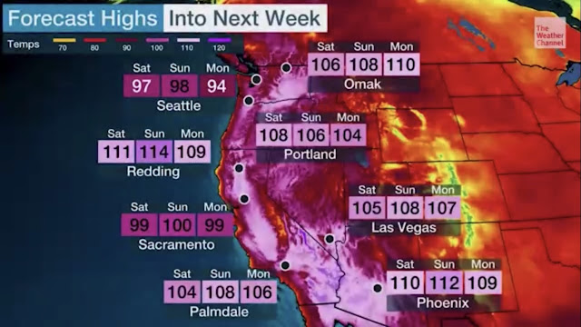
Upcoming forecast for the Western US, from The Weather Channel.

Good information about how to keep your home cool can be found here from Washington State Emergency Management's Twitter page:


Next Storm System Hits Western Washington

  8-26 Video Briefing: Next Storm System Hits Western Washington