It is now likely that the Seattle metro area will experience temperatures of 100+ degrees at times this weekend and possibly on Monday.
The Excessive Heat Watch will go into effect at 2 PM Friday until 9 PM Monday. The alert is below.
This is a very strongly worded alert, and for good reason. These will likely be our area's warmest temperatures in the last decade, with Portland and Eastern Washington possibly breaking all time records, and Seattle on the cusp of doing the same.
One thing that was not covered in the last blog post...why is this heat wave happening? Basically, it is due to a massive high pressure ridge, one of the strongest ever in our region. This ridge is created due to a West Pacific tropical disturbance creating waves in the jet stream, causing this ridge. The UW forecast model below shows the incredible ridge over the Pacific Northwest at 5 PM Sunday, near the peak of the heat wave.
The ridge is so large that it effectively deflects all other weather and puts us under a "heat dome" pattern, similar to what caused the very hot conditions in the Southwest recently. The Pacific Northwest is experiencing record heat because this heat dome is centered over our area, something that is quite abnormal.
Let's time things out for the upcoming days. This helpful timeline graphic from NWS Seattle shows what to expect each day and the impact of that day's weather. (Click to enlarge).
A single forecast (like the Weather Underground forecast I normally use) will not be accurate in this situation, since all forecasts are slightly different. The best idea is to take all the possibilities and average them, which is what's shown in the NWS Seattle graphics below, which show the highest possible high temp, lowest possible high temp, and the average.
Saturday:
Sunday:
Monday:
These are very warm temperatures, to say the least. Some forecasts show temperatures of 105+ degrees, mainly on Sunday and Monday. These predictions, while crazy, can't be counted out. Seemingly extreme values are still on the table at this point. More certainty on exact temperatures will become clear in the coming days.
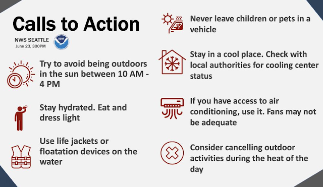
The most important thing to do is stay safe! If you can be in an air-conditioned space, take advantage of that opportunity. Below are some very helpful tips from NWS Seattle about beating the heat safely.
In short, this is a dangerous and unprecedented heat wave for the Pacific Northwest, on both sides of the Cascades.
Renowned Pacific Northwest meteorologist & UW professor Cliff Mass said on his blog today that "it is essentially certain that the Willamette Valley and western Washington from Seattle southward will have a historical heatwave, one beyond the experience of many residents."
Strong words from an experienced professional.
Stay tuned to this blog for further updates. I will do a daily update each evening until this heat wave is over.


No comments:
Post a Comment