Updated 9 AM Sunday with new Excessive Heat Warning & updated temperature forecasts
—————————————————————
The first day of the ongoing extreme heat wave is in the books. Temperatures were generally 1 to 4 degrees hotter than forecasts indicated. Saturday’s highs are below.
Temperatures ranged from the 90s by the water to 100-105+ inland. One particular temperature to notice is the 102 degree reading at Sea-Tac Airport. Saturday set the Seattle record for hottest June day (previously 96° in 2017) and became the 2nd hottest day ever recorded for the city. It was also the 3rd 100+ degree day in Seattle history.
Portland also set its new all-time record of 108 degrees today, breaking the old record of 107. This new record will likely be broken twice more in this heat wave.
Another aspect of Saturday’s weather were the muggy conditions and very high dewpoints. Record dewpoints of 68-75 degrees were recorded around the area. Some of these readings were reminiscent of the Eastern US. Expect dewpoints of 59-68 degrees through Monday. It’ll feel 2-5 degrees warmer than the actual temperature at times due to these dewpoints.
Looking ahead, the Excessive Heat Warning is in effect through 9 PM Monday. This important and strongly worded alert is below.
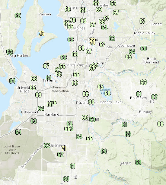
Nightly lows are quite warm, with all-time high nighttime temperatures expected on Saturday and Sunday nights. Lows will only reach 70-78 degrees, breaking the all time record of 71 degrees. Friday night’s lows are below, and they will seem “cool” compared to the upcoming lows.
As for high temperatures, the forecast just keeps getting hotter. In fact, Saturday’s forecast ended up being a few degrees too low, a potentially concerning trend if it keeps up for Sunday & Monday. Below are forecast temperatures for the valley & non-valley areas.
Sunday:
Valley: 104-110°
Non-valley: 102-108°
Monday:
Valley: 111-115°
Non-valley: 112-116°
Not only are these temperatures very extreme for our area, they are 2-12 degrees above all-time records, so there is no climatological comparison to them. All-time records will be shattered multiple days in a row.
With truly unprecedented temperatures likely, it is imperative that heat safety is the top priority. Below are two informative graphics from the National Weather Service showing heat safety and heat illness signs.
(I advise not being in the sun from 9 AM to 7 PM, in addition to the NWS recommendations)
These are important safety & medical tips that will save lives if implemented. Another good idea is to close your blinds/curtains before the sun hits them. This can help to keep a room cooler for a longer period of time.
Below is Sunday’s HeatRisk for Western Washington. Most of the area is under a high to very high risk.
Remember the warming downslope winds we talked about yesterday? Those didn’t really play a part on Saturday, and temperatures still got over 100 degrees. These winds will become more present on Sunday but especially Monday, and temperatures will be warmer as a result, especially near the Cascade foothills.
We are living through what is likely one of the most extreme and historic weather events in Pacific Northwest history. Some of the hottest days ever recorded in this area are ahead.


No comments:
Post a Comment