Monday, June 28th, 2021 will be one of the most remembered days in Pacific Northwest weather history. It was the hottest day ever across the western parts of Washington and Oregon, with many all-time records being set.
Below are Monday’s record-breaking highs in the South/Central Puget Sound area.
Just incredible. Highs ranged from 100-105 degrees where the Sound breeze caused some cooling to 105-115 degrees away from the water’s influence, easily the hottest temperatures ever in most areas.
Over the North/Central Sound, marine influence had a lesser presence, and nearly all temperatures ranged from 103-113 degrees, with a few upper 90s to low 100s near the Sound. Highs were 105-110 degrees on the Kitsap Peninsula.
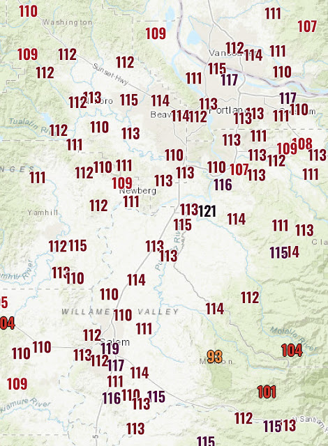
Because we can’t get enough of these incredible temperatures…below are the astounding temperatures in the Willamette Valley on Monday.
Portland and Salem both hit 117 degrees, setting a new record and tying the all-time record…for Las Vegas. How incredible is that?!?
Some all-time records set on Monday include:
Seattle (SeaTac): 108°; Olympia: 109°; Bremerton: 110°; Forks (Quillayute): 109°; Portland & Salem: 117°
Additionally…Dallesport, WA (across the Columbia River from The Dalles, OR) hit an incredible 118 degrees, which if verified would tie the Washington State all-time record high (118°, Ice Harbor Dam).
However, this record may not stand for long, as temperatures in the 115-120 degree range are likely in Eastern Washington on Tuesday. The poor residents of Eastern WA are now under an Excessive Heat Warning until July 4th…6 more days.
Thankfully, relief is coming to Western Washington as the thermal trough moves east. The map below, as of 9:30 PM Monday, shows cooler marine air bringing down temperatures in Thurston County and SW Pierce County.
The coast is cool, down in the 60s. The 70s-low 80s have made it to the Olympia area, and 60s have made it to Shelton. Further inland, the Tacoma/Federal Way area is slowly dropping below 90 degrees. Urban heat islands, such as South Tacoma, the Greater Seattle area, and the valleys are still in the 90s, and will be slower to cool down.
Monday night lows will drop to the mid-60s, still warm for Western Washington at night, but 5-7 degrees cooler than the previous nights.
Below is the Puyallup forecast from Weather Underground.
The main story is that well above average temperatures are likely for the rest of this week. Be sure to subtract 2-5 degrees outside the valleys & near water. Onshore flow will keep temperatures from getting above 95 degrees, but multiple days above 85 degrees are likely, considered “hot” weather for Western Washington.
Because of the recent extreme heat, photochemical reactions were triggered in the atmosphere that has produced hazy skies (smog) over the past few days.
This picture, taken by Gunner H., looking northwest from Bonney Lake at sunset on Monday gives an excellent visual of haze in the atmosphere.
This has brought air quality levels to moderate across the area. Not a huge hazard, and should get better with marine air.
We have made it through the hottest weather in Western Washington history! At least 10 days of temperatures above 80 degrees are ahead, with the hottest day on Tuesday (90-93 degrees). The Excessive Heat Warning remains in effect until 11 PM Tuesday.
This heat wave will remain in the memories of Pacific Northwest residents for many years. Now…the attention turns to Eastern Washington, where the state’s all-time record may be broken on Tuesday.


No comments:
Post a Comment