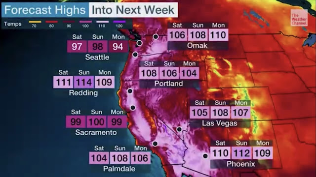
A major, record breaking heat wave is ahead for the Pacific Northwest. Temperatures of 95-100 degrees are likely for King & Pierce Counties, and all time records are in jeopardy in Portland & Eastern Washington.
Let’s start with the forecast for the next two days, before the heat builds. This is from Weather Underground for Puyallup.
Subtract a couple degrees outside the valley. Wednesday will possibly start cloudy and will be the “coolest” day for the foreseeable future. Thursday will be a few degrees warmer, with less clouds.
Now…we will break down the upcoming major heat wave.
To start, an Excessive Heat Watch is in effect from 2 PM Friday to 5 PM Monday. The alert is below.
Wow. This is a lot to unpack. This blog will cover what you'll need to know.
Let's start with the forecast for Puyallup.
For those living outside the valley, use this forecast for Federal Way.
The rule of thumb is to take off 2-3 degrees from valley temperatures for non-valley locations.
Temperatures of 95-105 degrees are likely from Saturday to Monday. These temperatures are extraordinary for Western Washington at any time of year, but even more so in June.
For perspective, Seattle has never reached above 96 degree in June, and the last 100+ degree day was in July 2009, almost 12 years ago.
There is still uncertainty in how hot the weekend will be. This informative graphic from NWS Seattle shows percent chance of temperatures exceeding 85, 95, 100, and 105 degrees.
For Saturday, there is a 75% chance of temperatures above 95 degrees, and a 35% chance of temperatures above 100 degrees.
Sunday will likely be the hottest day. Sunday has a 50% chance of temperatures above 100 degrees, and a 20% chance of 105+ degrees.
Monday will also be hot, with temperatures of 95-100 degrees possible. More information about Monday and the slow cooldown will become certain in the coming days.
Temperatures will generally be a degree or two warmer south of SeaTac airport, so theoretically, these percentages could be higher in Puyallup & surrounding areas.
Another major part of this event will be the very warm nighttime low temperatures. Lows of 65 to 70 degrees are likely from Friday night to Monday night.
In 2018, The Seattle Times reported that 34% of Seattle area homeowners have air conditioning, the lowest number of any major metro area in the United States (followed by San Francisco & Portland). This will exacerbate the impact of warm nighttime lows.
Below is a similar probability graphic from NWS Seattle, but this time for low temperatures.
The bottom line is that there is a 75+ percent chance of low temperatures greater than 65 degrees this weekend. Record low temperatures (below) could be tied or possibly broken.
High temperature records are likely around the area this weekend. The NWS graphic below shows current records for multiple cities in Western Washington.
Seattle’s daily records for Saturday, Sunday, and Monday will likely be broken.
In addition to the Western Washington heat, extreme heat is likely and all time records are in jeopardy in Portland and the Tri-Cities.
In Portland, two days of 108 degree temperatures are likely (Saturday & Sunday). The all time record of 107 degrees (set in 1965 & 1981) might not make it through the weekend.
In the Tri-Cities, the temperature will get very close to the all time record of 115 degrees (set in 1898 & 1939). The current forecast is 114-115 degrees.
Stay tuned for updates on the major heat wave. This is a fluctuating situation and some changes are likely. The bottom line is that very hot and dangerous temperatures are likely.


No comments:
Post a Comment